Forest Fire Assessment and Analysis in Liangshan, Sichuan Province Based on Remote Sensing


Article Information
Abstract
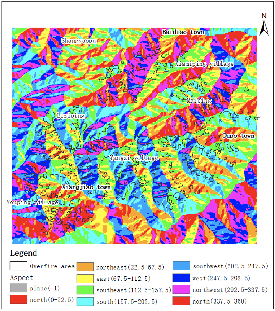
Because of the special geographical location, dry weather, high temperature and dense vegetation in Liangshan, Sichuan, it is easy to cause forest fires, so it is of great significance to use remote sensing data to evaluate forest fires in Liangshan, Sichuan. In this paper, the forest fire in Muli County, Liangshan, Sichuan Province on March 28th, 2020 was evaluated by using Landsat-8 remote sensing data which can be obtained free of charge. The NDVI of the pre-processed remote sensing images before and after the fire was calculated respectively. After the difference was made, the threshold of the classification of fire and non-fire areas was determined according to the maximum inter-class difference threshold method, and then the over-fire areas were extracted, and the interference was eliminated by open operation. And using the DEM data of the study area, combined with the topography of the study area, the over-fire area is analyzed. The results show that the "3.28" forest fire in Muli County, Sichuan Province, which is studied, belongs to a serious forest fire according to the burned area.
Graphical Abstract
Keywords
References
- Zheng, H., Wu, Z., & Wang, W. (2022). Forest fire risk assessment and prevention suggestions in heilongjiang province. Forestry Science & Technology, 47(1), 43–46.
[Google Scholar] - Chen, J., Du, C., Xie, F., & Lin, B. (2016). Allocation and scheduling of strictly periodic tasks in multi-core real-time systems. In Proceedings of the 22nd International Conference on Embedded and Real-time Computing Systems and Applications (pp. 130–138). Daegu, Korea (South).
[Google Scholar] - Indradjad, A., Sunarmodo, W., Salyasari, N., & Pratiknyo, B. (2019). Development of national forest/land fire monitoring system using remote sensing satellite data (terra/aqua modis and snpp) by automation and nearly real-time. In IOP Conference Series: Earth and Environmental Science (Vol. 280, p. 012032).
[Google Scholar] - Cai, W., Qian, P., Ding, Y., Bi, M., Ning, X., Hong, D., & Bai, X. (2023). Graph Structured Convolution-Guided Continuous Context Threshold-Aware Networks for Hyperspectral Image Classification. IEEE Transactions on Geoscience and Remote Sensing, doi: 10.1109/TGRS.2023.3323530.
[Google Scholar] - Cai, W., Gao, M., Ding, Y., Ning, X., Bai, X., & Qian, P. (2023). Stereo Attention Cross-Decoupling Fusion-Guided Federated Neural Learning for Hyperspectral Image Classification. IEEE Transactions on Geoscience and Remote Sensing, doi: 10.1109/TGRS.2023.3320044.
[Google Scholar] - p>
[Google Scholar] - Yang, Y., Chen, H., Chen, S., Qiu, D., & Wang, L. (2021). Fire spot recognition and post-fire assessment based on full infrared spectroscopy. Forestry and Ecological Sciences, 36(2), 170–178.
[Google Scholar] - Roy, D. P., Boschetti, L., & Trigg, S. N. (2006). Remote sensing of fire severity: assessing the performance of the normalized burn ratio. IEEE Geoscience and Remote Sensing Letters, 3(1), 112–116.
[Google Scholar] - Tan, L., Zeng, Y., & Zhong, Z. (2016). An adaptability analysis of remote sensing indices in evaluating fire severity. Remote Sensing for Natural Resources, 28(2), 84–90.
[Google Scholar] - Lu, Q., Wang, X., Cao, H., Li, W., & Wang, B. (2020). Remote sensing monitoring of forest fire in liangshan prefecture, sichuan province. Surveying and Mapping of Geology and Mineral Resources, 36(4), 9–12.
[Google Scholar] - Zhang, X. (2021). Research on prediction model and risk zoning of forest firess in liangshan prefecture, sichuan. Chengdu University Of Technology.
[Google Scholar] - Tang, Y., Wang, L., Zhao, J., & Wang, A. (2021). Monitoring "3-28" forest fire emergency disaster in sichuan muli based on remote sensing technology. Land and Resources Informatization (1), 12–18.
[Google Scholar] - Shi, Y., Mu, C., Tian, Y., Huang, Y., Guo, R., & Sun, X. (2022). Classification of main crops in jinta county of gansu province based on landsat-8 data. Geomatics & Spatial Information Technology, 45 (2), 74–78+81.
[Google Scholar] - Wu, W. (2022). Deep learning detection method of burned area based on landsat8 data. China University of Geosciences Beijing.
[Google Scholar] - Gemitzi, A., & Koutsias, N. (2022). A google earth engine code to estimate properties of vegetation phenology in fire affected areas–--a case study in north evia wildfire event on august 2021. Remote Sensing Applications: Society and Environment, 26, 100720.
[Google Scholar] - Rao, Y., Wang, C., & Huang, H. (2020). Forest fire monitoring based on multisensor remote sensing techniques in muli county, sichuan province. Journal of Remote Sensing, 24(5), 559–570.
[Google Scholar] - Ma, W. (2012). Design and implementation of pre-processing algorithm for part code recognition based on android platform. Beijing University of Posts and Telecommunications.
[Google Scholar] - Chen, Z. (2012). Remote sensing image processing based on gray morphology open operation. Technology Innovation and Application (10), 18.
[Google Scholar] - Dwornik, M., Porzycka-Strzelczyk, S., Strzelczyk, J., Malik, H., Murdzek, R., Franczyk, A., & Bala, J. (2021). Automatic detection of subsidence troughs in sar interferograms using mathematical morphology. Energies, 14(22), 7785.
[Google Scholar] - Zhang, Q. (2007). Study on the technology of large space fire detection based on image processing. Xihua University.
[Google Scholar] - Zhang, Y., Wang, M., & Wang, J. (2018). Risk analysis of forest firesand protection of forest resources in china based on information diffusion theory. Environmental Protection, 46(19), 38–43.
[Google Scholar] - Chen, J., Li, M., Yuan, Z., & Gu, Q. (2020). An improved a* algorithm for uav path planning problems. In Proceedings of the 4th Information Technology, Networking, Electronic and Automation Control Conference (Vol. 1, pp. 958–962). Chongqing, China.
[Google Scholar] - Nuthammachot, N., & Stratoulias, D. (2021). Multi-criteria decision analysis for forest fire risk assessment by coupling ahp and gis: Method and case study. Environment, Development and Sustainability, 1–16.
[Google Scholar] - Liu, M., Cheng, L., Gu, Y., Wang, Y., Liu, Q., & O’Connor, N. E. (2021). MPC-CSAS: Multi-party computation for real-time privacy-preserving speed advisory systems. IEEE Transactions on Intelligent Transportation Systems, 23(6), 5887-5893.
[Google Scholar] - Zhang, X., Cui, L., Shen, W., Zeng, J., Du, L., He, H., & Cheng, L. (2023). File processing security detection in multi-cloud environments: a process mining approach. Journal of Cloud Computing, 12(1), 100.
[Google Scholar] - Liu, C., Zeng, Q., Cheng, L., Duan, H., Zhou, M., & Cheng, J. (2021). Privacy-preserving behavioral correctness verification of cross-organizational workflow with task synchronization patterns. IEEE Transactions on Automation Science and Engineering, 18(3), 1037-1048.
[Google Scholar] - Li, J., Li, J., Xie, C., Liang, Y., Qu, K., Cheng, L., & Zhao, Z. (2023). PipCKG-BS: A Method to Build Cybersecurity Knowledge Graph for Blockchain Systems via the Pipeline Approach. Journal of Circuits, Systems and Computers, 2350274.
[Google Scholar] - Li, S., Li, J., Pei, J., Wu, S., Wang, S., & Cheng, L. (2023). Eco-CSAS: A Safe and Eco-Friendly Speed Advisory System for Autonomous Vehicle Platoon Using Consortium Blockchain. IEEE Transactions on Intelligent Transportation Systems.
[Google Scholar] - Chen, X., Yu, Q., Dai, S., Sun, P., Tang, H., & Cheng, L. (2023). Deep Reinforcement Learning for Efficient IoT Data Compression in Smart Railroad Management. IEEE Internet of Things Journal.
[Google Scholar] - Wang, Y., Wang, Y., Shi, C., Cheng, L., Li, H. and Li, X., (2020). An edge 3D CNN accelerator for low-power activity recognition. IEEE Transactions on Computer-Aided Design of Integrated Circuits and Systems, 40(5), pp.918-930.
[Google Scholar] - Cheng, L., Wang, Y., Liu, Q., Epema, D. H., Liu, C., Mao, Y., & Murphy, J. (2021). Network-aware locality scheduling for distributed data operators in data centers. IEEE Transactions on Parallel and Distributed Systems, 32(6), 1494-1510.
[Google Scholar] - Liu, J., Shen, H., Chi, H., Narman, H. S., Yang, Y., Cheng, L., & Chung, W. (2021). A low-cost multi-failure resilient replication scheme for high-data availability in cloud storage. IEEE/ACM Transactions on Networking, 29(4), 1436-1451.
[Google Scholar] - Chen, X., Cheng, L., Liu, C., Liu, Q., Liu, J., Mao, Y., & Murphy, J. (2020). A WOA-based optimization approach for task scheduling in cloud computing systems. IEEE Systems Journal, 14(3), 3117-3128.
[Google Scholar]
Cited By (4)
-
Yufei Wang, Ruixi Yang. .
Proceedings of the 2025 8th Artificial Intelligence and Cloud Computing Conference, 2025 .
[CrossRef] -
Zilin Wang, Ping Zhang, Weicheng Sun, Dongxu Li. Application of Dimension Reduction Methods to High-Dimensional Single-Cell 3D Genomic Contact Data.
IECE Transactions on Internet of Things, 2024 , 2 (1).
[CrossRef] -
Yue Zhao, Xingdong Wang, Zifan Zhang. Advancements in Multi-Year Ice Concentration Estimation from SSM/I 91.6GHz Observations.
IECE Transactions on Internet of Things, 2024 , 2 (1).
[CrossRef] -
Zhen Ye, Zhan Cao, Huan Liu, Haipeng Liu, Wei Li, Lin Bai, Xiaobo Li. Self-Supervised Learning With Multiscale Densely Connected Network for Hyperspectral Image Classification.
IEEE Transactions on Geoscience and Remote Sensing, 2024 , 62 .
[CrossRef]
Cite This Article
TY  - JOUR
AU  - Hua, Yiwei
AU  - Wang, Xingdong
PY  - 2023
DA  - 2023/10/17
TI  - Forest Fire Assessment and Analysis in Liangshan, Sichuan Province Based on Remote Sensing
JO  - ICCK Transactions on Internet of Things
T2  - ICCK Transactions on Internet of Things
JF  - ICCK Transactions on Internet of Things
VL  - 1
IS  - 1
SP  - 15
EP  - 21
DO  - 10.62762/TIOT.2023.862892
UR  - https://www.icck.org/article/abs/TIOT.2023.862892
KW  - Forest fire
KW  - Remote sensing assessment
KW  - NDVI
AB  - Because of the special geographical location, dry weather, high temperature and dense vegetation in Liangshan, Sichuan, it is easy to cause forest fires, so it is of great significance to use remote sensing data to evaluate forest fires in Liangshan, Sichuan. In this paper, the forest fire in Muli County, Liangshan, Sichuan Province on March 28th, 2020 was evaluated by using Landsat-8 remote sensing data which can be obtained free of charge. The NDVI of the pre-processed remote sensing images before and after the fire was calculated respectively. After the difference was made, the threshold of the classification of fire and non-fire areas was determined according to the maximum inter-class difference threshold method, and then the over-fire areas were extracted, and the interference was eliminated by open operation. And using the DEM data of the study area, combined with the topography of the study area, the over-fire area is analyzed. The results show that the "3.28" forest fire in Muli County, Sichuan Province, which is studied, belongs to a serious forest fire according to the burned area.
SN  - pending
PB  - Institute of Central Computation and Knowledge
LA  - English
ER  -
@article{Hua2023Forest,
  author = {Yiwei Hua and Xingdong Wang},
  title = {Forest Fire Assessment and Analysis in Liangshan, Sichuan Province Based on Remote Sensing},
  journal = {ICCK Transactions on Internet of Things},
  year = {2023},
  volume = {1},
  number = {1},
  pages = {15-21},
  doi = {10.62762/TIOT.2023.862892},
  url = {https://www.icck.org/article/abs/TIOT.2023.862892},
  abstract = {Because of the special geographical location, dry weather, high temperature and dense vegetation in Liangshan, Sichuan, it is easy to cause forest fires, so it is of great significance to use remote sensing data to evaluate forest fires in Liangshan, Sichuan. In this paper, the forest fire in Muli County, Liangshan, Sichuan Province on March 28th, 2020 was evaluated by using Landsat-8 remote sensing data which can be obtained free of charge. The NDVI of the pre-processed remote sensing images before and after the fire was calculated respectively. After the difference was made, the threshold of the classification of fire and non-fire areas was determined according to the maximum inter-class difference threshold method, and then the over-fire areas were extracted, and the interference was eliminated by open operation. And using the DEM data of the study area, combined with the topography of the study area, the over-fire area is analyzed. The results show that the "3.28" forest fire in Muli County, Sichuan Province, which is studied, belongs to a serious forest fire according to the burned area.},
  keywords = {Forest fire, Remote sensing assessment, NDVI},
  issn = {pending},
  publisher = {Institute of Central Computation and Knowledge}
}
Article Metrics
Publisher's Note
ICCK stays neutral with regard to jurisdictional claims in published maps and institutional affiliations.
Rights and Permissions

Portico