

EWLR - A New Method for Interpolating Elevation-Driven Variables: Annual Rainfall in Erbil Governorate


Article Information
Abstract
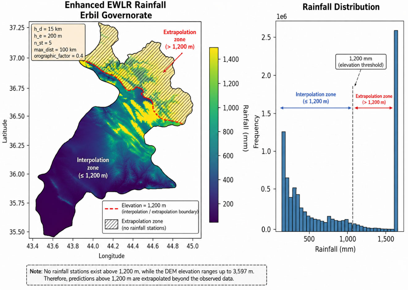
Accurate spatial estimation of rainfall is critical for hydrological modeling, water resource management, and agricultural planning---particularly in mountainous and semi-arid regions with sparse monitoring networks. This study presents an Enhanced Elevation-Weighted Local Regression (EWLR) model to generate a high-resolution (30~m) annual rainfall surface for Erbil Governorate, northern Iraq. The EWLR model integrates distance weighting, elevation similarity weighting, and orographic enhancement within a locally weighted regression framework. Average annual rainfall, derived from rainy seasons spanning 1997--1998 to 2024--2025 across 19 meteorological stations, along with a 30~m resolution digital elevation model (DEM), were used to construct and validate the model. Hyperparameters were optimized via Leave-One-Out Cross-Validation (LOOCV), and performance was benchmarked against conventional methods including Inverse Distance Weighting (IDW), Kriging, Thin-Plate Spline, and Radial Basis Function interpolation. Results indicate that EWLR outperforms all benchmarks, achieving $R^2 = 0.797$, RMSE $= 120.9$~mm, and MAE $= 87.46$~mm. Rainfall shows a strong positive correlation with elevation ($r = 0.907$, $p < 0.001$), increasing nearly fivefold from lowland plains ($\sim$270~mm) to mountainous areas ($>$1{,}300~mm). The final high-resolution rainfall map captures orographic effects reasonably well, providing a physically consistent, statistically robust dataset suitable for hydrological, climatic, and environmental modeling in data-sparse mountainous regions. The methodology offers a reproducible, elevation-centric framework adaptable to other elevation-driven variables (e.g., temperature lapse rates or snow accumulation) and complex terrains with limited observations.
Graphical Abstract
Keywords
Data Availability Statement
Funding
Conflicts of Interest
AI Use Statement
Ethical Approval and Consent to Participate
References
- Houze Jr, R. A. (2012). Orographic effects on precipitating clouds. Reviews of Geophysics, 50(1).
[CrossRef] [Google Scholar] - Roe, G. H. (2005). Orographic precipitation. Annual Review of Earth and Planetary Sciences, 33(1), 645-671.
[CrossRef] [Google Scholar] - Alijani, B. (2008). Effect of the Zagros Mountains on the spatial distribution of precipitation. Journal of Mountain Science, 5(3), 218-231.
[CrossRef] [Google Scholar] - Aljaff, M. A. (2025). Trend and variability of rainfall in recent years in Iraq: A physical perspective. International Journal of Science and Research Archive, 14(2), 1118-1128.
[CrossRef] [Google Scholar] - Alsafadi, K., Bi, S., Bashir, B., Sharifi, E., Alsalman, A., Kumar, A., & Shahid, S. (2023). High-resolution precipitation modeling in complex terrains using hybrid interpolation techniques: Incorporating physiographic and MODIS cloud cover influences. Remote Sensing, 15(9), 2435.
[CrossRef] [Google Scholar] - Muter, S. A., Al-Jiboori, M. H., & Al-Timimi, Y. K. (2025). Assessment of spatial and temporal monthly rainfall trend over Iraq. Baghdad Science Journal, 22(3), 910-922.
[CrossRef] [Google Scholar] - Forti, L., Perego, A., Brandolini, F., Mariani, G. S., Zebari, M., Nicoll, K., ... & Zerboni, A. (2021). Geomorphology of the northwestern Kurdistan Region of Iraq: landscapes of the Zagros Mountains drained by the Tigris and Great Zab Rivers. Journal of Maps, 17(2), 225-236.
[CrossRef] [Google Scholar] - Doski, J. A., & McClay, K. (2022). Tectono-stratigraphic evolution, regional structure and fracture patterns of the Zagros fold-thrust belt in the Duhok region, Kurdistan, northern Iraq. Tectonophysics, 838, 229506.
[CrossRef] [Google Scholar] - Gaznayee, H. A. A., Al-Quraishi, A. M. F., Mahdi, K., & Ritsema, C. (2022). A geospatial approach for analysis of drought impacts on vegetation cover and land surface temperature in the Kurdistan Region of Iraq. Water, 14(6), 927.
[CrossRef] [Google Scholar] - Forti, L., Pelfini, M., Sissakian, V. K., & Zerboni, A. (2023). Settling the riverscape of Erbil (Kurdistan Region of Iraq): long-term human overprint on landforms and present-day geomorphological hazard. Anthropocene, 44, 100413.
[CrossRef] [Google Scholar] - Zandi, O., Nasseri, M., & Zahraie, B. (2023). A locally weighted linear ridge regression framework for spatial interpolation of monthly precipitation over an orographically complex area. International Journal of Climatology, 43(6), 2601-2622.
[CrossRef] [Google Scholar] - Goovaerts, P. (2000). Geostatistical approaches for incorporating elevation into the spatial interpolation of rainfall. Journal of hydrology, 228(1-2), 113-129.
[CrossRef] [Google Scholar] - Mustafa, A. M., Muhammed, H., & Szydłowski, M. (2019). Extreme rainfalls as a cause of urban flash floods: A case study of the Erbil-Kurdistan region of Iraq. Journal of Water and Land Development, 42, 113-132. http://doi.org/10.15576/ASP.FC/2019.18.3.113
[Google Scholar] - Dura, V., Evin, G., Favre, A. C., & Penot, D. (2025). Improving precipitation interpolation using anisotropic variograms derived from convection-permitting regional climate model simulations. EGUsphere, 2025, 1-25.
[CrossRef] [Google Scholar] - Workneh, H. T., Chen, X., Ma, Y., Bayable, E., & Dash, A. (2024). Comparison of IDW, Kriging and orographic based linear interpolations of rainfall in six rainfall regimes of Ethiopia. Journal of Hydrology: Regional Studies, 52, 101696.
[CrossRef] [Google Scholar] - Javari, M. (2017). Assessment of temperature and elevation controls on spatial variability of rainfall in Iran. Atmosphere, 8(3), 45.
[CrossRef] [Google Scholar] - Alsafadi, K., Mohammed, S., Mokhtar, A., Sharaf, M., & He, H. (2021). Fine-resolution precipitation mapping over Syria using local regression and spatial interpolation. Atmospheric Research, 256, 105524.
[CrossRef] [Google Scholar] - Hajani, E., Shajee, K., Kaleel, F., & Abdulhaq, H. (2022). Characteristics of changes in rainfall data in the Kurdistan Region, Iraq. Arabian Journal of Geosciences, 15(6), 509.
[CrossRef] [Google Scholar] - Gottardi, F., Obled, C., Gailhard, J., & Paquet, E. (2012). Statistical reanalysis of precipitation fields based on ground network data and weather patterns: Application over French mountains. Journal of Hydrology, 432, 154-167.
[CrossRef] [Google Scholar] - Bertoncini, A., & Pomeroy, J. W. (2025). Quantifying spatiotemporal and elevational precipitation gauge network uncertainty in the Canadian Rockies. Hydrology and Earth System Sciences, 29(4), 983-1000.
[CrossRef] [Google Scholar] - Xiaojun, G., Peng, C., Xingchang, C., Yong, L., Ju, Z., & Yuqing, S. (2021). Spatial uncertainty of rainfall and its impact on hydrological hazard forecasting in a small semiarid mountainous watershed. Journal of Hydrology, 595, 126049.
[CrossRef] [Google Scholar] - Bandar, Q. K. A., & Muslih, K. D. (2025). Spatial assessment of precipitation concentration and seasonality in Iraq. Theoretical and Applied Climatology, 156(2), 134.
[CrossRef] [Google Scholar] - Bárdossy, A., & Pegram, G. (2013). Interpolation of precipitation under topographic influence at different time scales. Water Resources Research, 49(8), 4545-4565.
[CrossRef] [Google Scholar] - Pohjankukka, J., Pahikkala, T., Nevalainen, P., & Heikkonen, J. (2017). Estimating the prediction performance of spatial models via spatial k-fold cross validation. International Journal of Geographical Information Science, 31(10), 2001-2019.
[CrossRef] [Google Scholar] - Aziz, A. A., Omer, P. A., & Kak Ahmed Khayyat, H. A. (2026). Assessing The Accuracy of Satellite Rainfall Data for Erbil city. Passer Journal of Basic and Applied Sciences, 8(1), 146-176.
[CrossRef] [Google Scholar] - Morsy, M., Taghizadeh-Mehrjardi, R., Michaelides, S., Scholten, T., Dietrich, P., & Schmidt, K. (2021). Optimization of rain gauge networks for arid regions based on remote sensing data. Remote Sensing, 13(21), 4243.
[CrossRef] [Google Scholar] - Daly, C., Halbleib, M., Smith, J. I., Gibson, W. P., Doggett, M. K., Taylor, G. H., ... & Pasteris, P. P. (2008). Physiographically sensitive mapping of climatological temperature and precipitation across the conterminous United States. International Journal of Climatology: a Journal of the Royal Meteorological Society, 28(15), 2031-2064.
[CrossRef] [Google Scholar] - Sekulić, A., Kilibarda, M., Heuvelink, G. B., Nikolić, M., & Bajat, B. (2020). Random forest spatial interpolation. Remote Sensing, 12(10), 1687.
[CrossRef] [Google Scholar]
Cite This Article
TY  - JOUR
AU  - Rasul, Azad
PY  - 2026
DA  - 2026/09/24
TI  - EWLR - A New Method for Interpolating Elevation-Driven Variables: Annual Rainfall in Erbil Governorate
JO  - Journal of Geoscience and Earth Observation
T2  - Journal of Geoscience and Earth Observation
JF  - Journal of Geoscience and Earth Observation
VL  - 1
IS  - 2
SP  - 158
EP  - 171
DO  - 10.62762/JGEO.2026.171666
UR  - https://www.icck.org/article/abs/JGEO.2026.171666
KW  - rainfall interpolation
KW  - Elevation-Weighted Local Regression (EWLR)
KW  - orographic enhancement
KW  - Kurdistan Region
KW  - mountainous terrain
KW  - spatial precipitation mapping
KW  - hydrological modeling
AB  - Accurate spatial estimation of rainfall is critical for hydrological modeling, water resource management, and agricultural planning---particularly in mountainous and semi-arid regions with sparse monitoring networks. This study presents an Enhanced Elevation-Weighted Local Regression (EWLR) model to generate a high-resolution (30~m) annual rainfall surface for Erbil Governorate, northern Iraq. The EWLR model integrates distance weighting, elevation similarity weighting, and orographic enhancement within a locally weighted regression framework. Average annual rainfall, derived from rainy seasons spanning 1997--1998 to 2024--2025 across 19 meteorological stations, along with a 30~m resolution digital elevation model (DEM), were used to construct and validate the model. Hyperparameters were optimized via Leave-One-Out Cross-Validation (LOOCV), and performance was benchmarked against conventional methods including Inverse Distance Weighting (IDW), Kriging, Thin-Plate Spline, and Radial Basis Function interpolation. Results indicate that EWLR outperforms all benchmarks, achieving $R^2 = 0.797$, RMSE $= 120.9$~mm, and MAE $= 87.46$~mm. Rainfall shows a strong positive correlation with elevation ($r = 0.907$, $p < 0.001$), increasing nearly fivefold from lowland plains ($\sim$270~mm) to mountainous areas ($>$1{,}300~mm). The final high-resolution rainfall map captures orographic effects reasonably well, providing a physically consistent, statistically robust dataset suitable for hydrological, climatic, and environmental modeling in data-sparse mountainous regions. The methodology offers a reproducible, elevation-centric framework adaptable to other elevation-driven variables (e.g., temperature lapse rates or snow accumulation) and complex terrains with limited observations.
SN  - 3144-2692
PB  - Institute of Central Computation and Knowledge
LA  - English
ER  -
@article{Rasul2026EWLR,
  author = {Azad Rasul},
  title = {EWLR - A New Method for Interpolating Elevation-Driven Variables: Annual Rainfall in Erbil Governorate},
  journal = {Journal of Geoscience and Earth Observation},
  year = {2026},
  volume = {1},
  number = {2},
  pages = {158-171},
  doi = {10.62762/JGEO.2026.171666},
  url = {https://www.icck.org/article/abs/JGEO.2026.171666},
  abstract = {Accurate spatial estimation of rainfall is critical for hydrological modeling, water resource management, and agricultural planning---particularly in mountainous and semi-arid regions with sparse monitoring networks. This study presents an Enhanced Elevation-Weighted Local Regression (EWLR) model to generate a high-resolution (30~m) annual rainfall surface for Erbil Governorate, northern Iraq. The EWLR model integrates distance weighting, elevation similarity weighting, and orographic enhancement within a locally weighted regression framework. Average annual rainfall, derived from rainy seasons spanning 1997--1998 to 2024--2025 across 19 meteorological stations, along with a 30~m resolution digital elevation model (DEM), were used to construct and validate the model. Hyperparameters were optimized via Leave-One-Out Cross-Validation (LOOCV), and performance was benchmarked against conventional methods including Inverse Distance Weighting (IDW), Kriging, Thin-Plate Spline, and Radial Basis Function interpolation. Results indicate that EWLR outperforms all benchmarks, achieving \$R^2 = 0.797\$, RMSE \$= 120.9\$~mm, and MAE \$= 87.46\$~mm. Rainfall shows a strong positive correlation with elevation (\$r = 0.907\$, \$p < 0.001\$), increasing nearly fivefold from lowland plains (\$\sim\$270~mm) to mountainous areas (\$>\$1{,}300~mm). The final high-resolution rainfall map captures orographic effects reasonably well, providing a physically consistent, statistically robust dataset suitable for hydrological, climatic, and environmental modeling in data-sparse mountainous regions. The methodology offers a reproducible, elevation-centric framework adaptable to other elevation-driven variables (e.g., temperature lapse rates or snow accumulation) and complex terrains with limited observations.},
  keywords = {rainfall interpolation, Elevation-Weighted Local Regression (EWLR), orographic enhancement, Kurdistan Region, mountainous terrain, spatial precipitation mapping, hydrological modeling},
  issn = {3144-2692},
  publisher = {Institute of Central Computation and Knowledge}
}
Article Metrics
Publisher's Note
ICCK stays neutral with regard to jurisdictional claims in published maps and institutional affiliations.
Rights and Permissions
 Copyright © 2026 by the Author(s). Published by Institute of Central Computation and Knowledge. This article is an open access article distributed under the terms and conditions of the Creative Commons Attribution (CC BY) license (https://creativecommons.org/licenses/by/4.0/), which permits use, sharing, adaptation, distribution and reproduction in any medium or format, as long as you give appropriate credit to the original author(s) and the source, provide a link to the Creative Commons licence, and indicate if changes were made.


Portico
