

Assessing The Impact of Sea Encroachment in Ilaje, Ondo State, Using Optical Satellite Imagery Analysis and Shuttle Radar Topography Mission


Article Information
Abstract
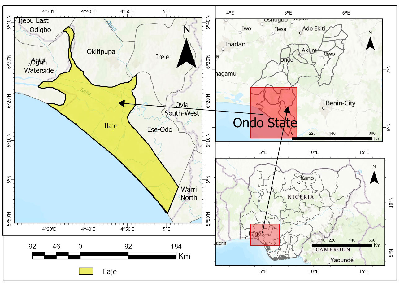
This study assessed the impacts of sea encroachment in Ilaje Local Government Area of Ondo State, Nigeria, using multi-temporal optical satellite imagery and the Shuttle Radar Topography Mission (SRTM) Digital Elevation Model (DEM). This study analyzed past and recent shoreline change trends, simulated elevation-based vulnerability to flooding, and predicted the potential effects of sea-level rise. Landsat images from 1995, 2000, 2005, 2010, 2015, 2020, and 2025 were analyzed to identify the shoreline, and shoreline changes were calculated using the End Point Rate (EPR) and Linear Regression Rate (LRR) in the Digital Shoreline Analysis System (DSAS). Elevation-based vulnerability maps were modeled using the SRTM DEM, and future inundation was projected using sea-level rise data. Results showed that erosion was more severe along the Ilaje coastline, with over 70 percent of the shoreline retreating at different rates, while only small sections experienced accretion. The inundation model, assuming a conservative rise of 0.269 m, indicated that more than 555 km$^2$ of land could be submerged, and a 1m rise could flood over 650 km$^2$ by the year 2150, an event that would affect settlements such as Ayetoro, Ogogoro, and Gbeke Eke. These findings emphasize why Ilaje communities are at risk of land loss, displacement, and livelihood impacts. The analysis concludes that sea intrusion poses a significant threat to the coastal ecosystem in Ilaje. This study recommends integrating the coastal zone into planning efforts, restoring mangroves as natural barriers, adopting stricter measures to prevent unsustainable human activities, and maintaining ongoing geospatial monitoring as part of a sustainable strategy for change.
Graphical Abstract
Keywords
Data Availability Statement
Funding
Conflicts of Interest
AI Use Statement
Ethical Approval and Consent to Participate
References
- Wantim, M. N., Mokosa, W. A., Jitiz, L., & Ayonghe, S. N. (2021). The utilisation of satellite imagery and community perceptions to assess the impacts of sea encroachment in the West Coast of Cameroon at Limbe. Journal Of The Cameroon Academy Of Sciences, 16(3).
[CrossRef] [Google Scholar] - Dada, O. A., Almar, R., & Morand, P. (2024). Coastal vulnerability assessment of the West African coast to flooding and erosion. Scientific reports, 14(1), 890.
[CrossRef] [Google Scholar] - Intergovernmental Panel on Climate Change. (2014). Climate change 2013: The physical science basis. Contribution of working group I to the fifth assessment report of the Intergovernmental Panel on Climate Change. T. F. Stocker, D. Qin, G.-K. Plattner, M. M. B. Tignor, S. K. Allen, J. Boschung, A. Nauels, Y. Xia, V. Bex, & P. M. Midgley (Eds.). Cambridge University Press.
[CrossRef] [Google Scholar] - Cazenave, A., Meyssignac, B., Ablain, M., Balmaseda, M., Bamber, J., Barletta, V., ... & Wouters, B. (2018). Global sea-level budget 1993-present. Earth System Science Data, 10(3), 1551-1590.
[CrossRef] [Google Scholar] - Gbedemah, S. F., Amenyogbe, G. K., Frimpong, L. K., & Mensah, L. S. (2023, August). The Impact of Tidal Waves on Coastal Communities and the Resilient Strategies of People Around Keta and Anloga Communities in Ghana. In Applied Research Conference in Africa (pp. 391-406). Cham: Springer Nature Switzerland.
[CrossRef] [Google Scholar] - Dada, O. A., Almar, R., & Oladapo, M. I. (2020). Recent coastal sea-level variations and flooding events in the Nigerian Transgressive Mud coast of Gulf of Guinea. Journal of African Earth Sciences, 161, 103668.
[CrossRef] [Google Scholar] - Wong, P. P., Losada, I. J., Amez, S., Gattuso, J. P., Hinkel, J., Khattabi, A., ... & Santos, F. (2015). Coastal systems and low-lying areas. In Climate change 2014 impacts, adaptation and vulnerability: part a: global and sectoral aspects (pp. 361-410). https://hdl.handle.net/10779/uow.27702801
[Google Scholar] - Bukvic, A., Rohat, G., Apotsos, A., & de Sherbinin, A. (2020). A systematic review of coastal vulnerability mapping. Sustainability, 12(7), 2822.
[CrossRef] [Google Scholar] - Merkens, J. L., Reimann, L., Hinkel, J., & Vafeidis, A. T. (2016). Gridded population projections for the coastal zone under the Shared Socioeconomic Pathways. Global and Planetary Change, 145, 57-66.
[CrossRef] [Google Scholar] - Sarr, C. A. T., Ndour, M. M. M., Haddad, M., & Sakho, I. (2021). Estimation of sea level rise on the West African coasts: Case of Senegal, Mauritania and Cape Verde. International Journal of Geosciences, 12, 121-137.
[CrossRef] [Google Scholar] - Tano, R. A., Aman, A., Toualy, E., Kouadio, Y. K., François-Xavier, B. B. D., & Addo, K. A. (2018). Development of an integrated coastal vulnerability index for the Ivorian coast in West Africa. Journal of Environmental Protection, 9(11), 1171-1184.
[CrossRef] [Google Scholar] - Jayson-Quashigah, P. N., Addo, K. A., & Kodzo, K. S. (2013). Medium resolution satellite imagery as a tool for monitoring shoreline change. Case study of the Eastern coast of Ghana. Journal of coastal Research, 65(SI), 511-516.
[CrossRef] [Google Scholar] - Mucova, S. A. R., Azeiteiro, U. M., Filho, W. L., Lopes, C. L., Dias, J. M., & Pereira, M. J. (2021). Approaching Sea-Level Rise (SLR) change: strengthening local responses to sea-level rise and coping with climate change in Northern Mozambique. Journal of Marine Science and Engineering, 9(2), 205.
[CrossRef] [Google Scholar] - Efere, Z., & Ohwo, O. (2022). Vulnerability of Coastal Communities to Sea Level Rise in Brass Local Government Area, Nigeria. Nigerian Journal of Environmental Sciences and Technology, 6(1), 112-123. https://www.researchgate.net/publication/359523961
[Google Scholar] - Isiaka, I., & Tata, H. (2024). Futuristic prediction of the lagoon coast shorelines using spaceborne Synthetic Aperture Radar (SAR) imagery. Nova Geodesia, 4(2), 184.
[CrossRef] [Google Scholar] - Intergovernmental Panel on Climate Change. (2021). Climate Change 2021: The Physical Science Basis. Contribution of Working Group I to the Sixth Assessment Report of the Intergovernmental Panel on Climate Change. V. Masson-Delmotte, P. Zhai, A. Pirani, S. L. Connors, C. Péan, S. Berger, N. Caud, Y. Chen, L. Goldfarb, M. I. Gomis, M. Huang, K. Leitzell, E. Lonnoy, J. B. R. Matthews, T. K. Maycock, T. Waterfield, O. Yelekçi, R. Yu, & B. Zhou (Eds.). Cambridge University Press. https://www.ipcc.ch/report/ar6/wg1/
[Google Scholar] - Popoola O.O. (2022). Spatio-Temporal Assessment of Shoreline Changes and Management of the Transgressive Mud Coast, Nigeria. European Scientific Journal, 18(20), 99.
[CrossRef] [Google Scholar] - Opoola, L. O., Ibitoye, M. O., Komolafe, A. A., & Dada, O. A. (2025). Geospatial analysis of shoreline changes along the Southwestern coast of Nigeria over the past four decades. Environmental Monitoring and Assessment, 197(10), 1165.
[CrossRef] [Google Scholar] - Atayi, J., Twumasi, Y. A., Ning, Z. H., & Asare-Ansah, A. B. (2022). A study on the shoreline changes and land use/land cover along the Keta coastal zone. The International Archives of the Photogrammetry, Remote Sensing and Spatial Information Sciences, 46, 39-45.
[CrossRef] [Google Scholar] - Hastuti, A. W., Nagai, M., & Suniada, K. I. (2022). Coastal vulnerability assessment of Bali Province, Indonesia using remote sensing and GIS approaches. Remote Sensing, 14(17), 4409.
[CrossRef] [Google Scholar] - Adeaga, O., Folorunsho, R., Foli, B. A. K., & Akinbaloye, O. (2021). Assessment of shoreline change along the coast of Lagos, Nigeria. Remote Sensing in Earth Systems Sciences, 4(3), 186-198.
[CrossRef] [Google Scholar] - Dada, O. A., Agbaje, A. O., Adesina, R. B., & Asiwaju-Bello, Y. A. (2019). Effect of coastal land use change on coastline dynamics along the Nigerian Transgressive Mahin mud coast. Ocean & Coastal Management, 168, 251-264.
[CrossRef] [Google Scholar] - Ogunrayi, O. A., Mattah, P. A. D., Folorunsho, R., Jolaiya, E., & Ikuomola, O. J. (2023). A spatio-temporal analysis of shoreline changes in the Ilaje coastal area of Ondo state, Nigeria. Journal of Marine Science and Engineering, 12(1), 18.
[CrossRef] [Google Scholar] - Fashae, O. A., & Onafeso, O. D. (2011). Impact of climate change on sea level rise in Lagos, Nigeria. International journal of remote sensing, 32(24), 9811-9819.
[CrossRef] [Google Scholar] - Komolafe, A. A., Apalara, P. A., Ibitoye, M. O., Adebola, A. O., Olorunfemi, I. E., & Diallo, I. (2022). Spatio-temporal analysis of shoreline positional change of Ondo State coastline using remote sensing and GIS: A case study of Ilaje coastline at Ondo State in Nigeria. Earth Systems and Environment, 6(1), 281-293.
[CrossRef] [Google Scholar] - Omitoyin, S. A., Ogungbure, A. P., & Osakuade, K. D. (2021). Assessment of Livelihood Vulnerability of Fisherfolks in Coastal and Freshwater Fishing Communities of Ilaje in Ondo State. Asian Journal of Fisheries and Aquatic Research, 11(2), 1-14.
[CrossRef] [Google Scholar] - National Population Commission (NPC). (2006). Population and Housing Census of the Federal Republic of Nigeria: National and State Population and Housing Tables. Abuja, Nigeria. https://searchworks.stanford.edu/view/8626165
[Google Scholar]
Cite This Article
TY  - JOUR
AU  - Adewumi, Blessing Banji
AU  - Tata, Herbert
AU  - Awoleye, Kolawole Daniel
PY  - 2026
DA  - 2026/08/20
TI  - Assessing The Impact of Sea Encroachment in Ilaje, Ondo State, Using Optical Satellite Imagery Analysis and Shuttle Radar Topography Mission
JO  - Journal of Geoscience and Earth Observation
T2  - Journal of Geoscience and Earth Observation
JF  - Journal of Geoscience and Earth Observation
VL  - 1
IS  - 2
SP  - 101
EP  - 112
DO  - 10.62762/JGEO.2026.327931
UR  - https://www.icck.org/article/abs/JGEO.2026.327931
KW  - coastal management
KW  - sea encroachment
KW  - Ilaje
KW  - sea-level rise
KW  - shoreline change
KW  - inundation models
AB  - This study assessed the impacts of sea encroachment in Ilaje Local Government Area of Ondo State, Nigeria, using multi-temporal optical satellite imagery and the Shuttle Radar Topography Mission (SRTM) Digital Elevation Model (DEM). This study analyzed past and recent shoreline change trends, simulated elevation-based vulnerability to flooding, and predicted the potential effects of sea-level rise. Landsat images from 1995, 2000, 2005, 2010, 2015, 2020, and 2025 were analyzed to identify the shoreline, and shoreline changes were calculated using the End Point Rate (EPR) and Linear Regression Rate (LRR) in the Digital Shoreline Analysis System (DSAS). Elevation-based vulnerability maps were modeled using the SRTM DEM, and future inundation was projected using sea-level rise data. Results showed that erosion was more severe along the Ilaje coastline, with over 70 percent of the shoreline retreating at different rates, while only small sections experienced accretion. The inundation model, assuming a conservative rise of 0.269 m, indicated that more than 555 km$^2$ of land could be submerged, and a 1m rise could flood over 650 km$^2$ by the year 2150, an event that would affect settlements such as Ayetoro, Ogogoro, and Gbeke Eke. These findings emphasize why Ilaje communities are at risk of land loss, displacement, and livelihood impacts. The analysis concludes that sea intrusion poses a significant threat to the coastal ecosystem in Ilaje. This study recommends integrating the coastal zone into planning efforts, restoring mangroves as natural barriers, adopting stricter measures to prevent unsustainable human activities, and maintaining ongoing geospatial monitoring as part of a sustainable strategy for change.
SN  - pending
PB  - Institute of Central Computation and Knowledge
LA  - English
ER  -
@article{Adewumi2026Assessing,
  author = {Blessing Banji Adewumi and Herbert Tata and Kolawole Daniel Awoleye},
  title = {Assessing The Impact of Sea Encroachment in Ilaje, Ondo State, Using Optical Satellite Imagery Analysis and Shuttle Radar Topography Mission},
  journal = {Journal of Geoscience and Earth Observation},
  year = {2026},
  volume = {1},
  number = {2},
  pages = {101-112},
  doi = {10.62762/JGEO.2026.327931},
  url = {https://www.icck.org/article/abs/JGEO.2026.327931},
  abstract = {This study assessed the impacts of sea encroachment in Ilaje Local Government Area of Ondo State, Nigeria, using multi-temporal optical satellite imagery and the Shuttle Radar Topography Mission (SRTM) Digital Elevation Model (DEM). This study analyzed past and recent shoreline change trends, simulated elevation-based vulnerability to flooding, and predicted the potential effects of sea-level rise. Landsat images from 1995, 2000, 2005, 2010, 2015, 2020, and 2025 were analyzed to identify the shoreline, and shoreline changes were calculated using the End Point Rate (EPR) and Linear Regression Rate (LRR) in the Digital Shoreline Analysis System (DSAS). Elevation-based vulnerability maps were modeled using the SRTM DEM, and future inundation was projected using sea-level rise data. Results showed that erosion was more severe along the Ilaje coastline, with over 70 percent of the shoreline retreating at different rates, while only small sections experienced accretion. The inundation model, assuming a conservative rise of 0.269 m, indicated that more than 555 km\$^2\$ of land could be submerged, and a 1m rise could flood over 650 km\$^2\$ by the year 2150, an event that would affect settlements such as Ayetoro, Ogogoro, and Gbeke Eke. These findings emphasize why Ilaje communities are at risk of land loss, displacement, and livelihood impacts. The analysis concludes that sea intrusion poses a significant threat to the coastal ecosystem in Ilaje. This study recommends integrating the coastal zone into planning efforts, restoring mangroves as natural barriers, adopting stricter measures to prevent unsustainable human activities, and maintaining ongoing geospatial monitoring as part of a sustainable strategy for change.},
  keywords = {coastal management, sea encroachment, Ilaje, sea-level rise, shoreline change, inundation models},
  issn = {pending},
  publisher = {Institute of Central Computation and Knowledge}
}
Article Metrics
Publisher's Note
ICCK stays neutral with regard to jurisdictional claims in published maps and institutional affiliations.
Rights and Permissions
 Copyright © 2026 by the Author(s). Published by Institute of Central Computation and Knowledge. This article is an open access article distributed under the terms and conditions of the Creative Commons Attribution (CC BY) license (https://creativecommons.org/licenses/by/4.0/), which permits use, sharing, adaptation, distribution and reproduction in any medium or format, as long as you give appropriate credit to the original author(s) and the source, provide a link to the Creative Commons licence, and indicate if changes were made.


Portico
