

Integration of Gis and Multi-Criteria Evaluation for Land Suitability Assessment of Arable Crops in Ondo State, Nigeria


Article Information
Abstract
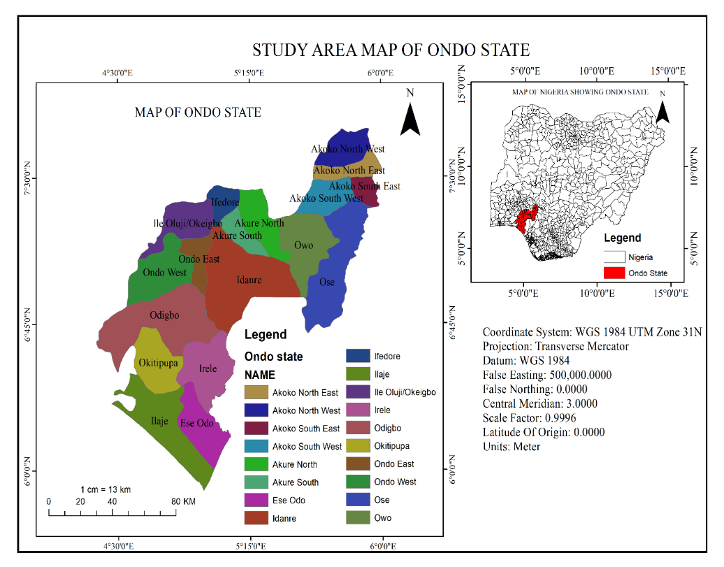
Agriculture plays a vital role in Nigeria’s food security and economy, yet crop productivity depends heavily on land suitability. This study assessed the suitability of land for arable crops in Ondo State using Geographic Information System (GIS) and Multi-Criteria Evaluation (MCE) techniques. Nineteen (19) parameters, including soil, hydrogeomorphological, climatic, land-use/land-cover, and socioeconomic factors, were integrated. Datasets were obtained from sources such as Sentinel-2 Dynamic World, SRTM DEM, MODIS temperature, CHRS rainfall, ISRIC soils, and OpenStreetMap. The criteria were normalised, reclassified, and weighted using the Analytic Hierarchy Process (AHP). Weighted overlay analysis was then performed to generate suitability maps for Maize, Cassava, Yams, Plantain, and Vegetables. Results showed clear spatial variations in suitability. Plantain was the most suitable crop in S1 (12.01%). Maize followed with 7.34% in S1. Yam had the highest percentage (29.88%) in S2, indicating widespread suitability across the state. Cassava dominated in S4 (26.52%) but faced more constraints. Vegetables had the least in S1 (6.72%) and the highest in N (11.67%), making them the least suitable. Final outputs were presented as thematic maps to aid visualisation and decision-making. The study concludes that GIS-based land suitability assessment is a reliable tool for optimising arable crop cultivation in Ondo State. It highlighted highly suitable zones and identified limiting factors; the results provide evidence-based guidance for farmers, policymakers, and agricultural planners. This study recommends adopting the generated maps for land allocation, crop planning, and agricultural policy to improve yields and ensure sustainable land use.
Graphical Abstract
Keywords
Data Availability Statement
Funding
Conflicts of Interest
AI Use Statement
Ethical Approval and Consent to Participate
References
- FAO. (2017). The future of food and agriculture: Trends and challenges. Food and Agriculture Organisation of the United Nations. Available at: https://openknowledge.fao.org/handle/20.500.14283/i6583e
[Google Scholar] - Tittonell, P., & Giller, K. E. (2013). When yield gaps are poverty traps: The paradigm of ecological intensification in African smallholder agriculture. Field Crops Research, 143, 76-90.
[CrossRef] [Google Scholar] - Pingali, P. L. (2012). Green revolution: impacts, limits, and the path ahead. Proceedings of the national academy of sciences, 109(31), 12302-12308.
[CrossRef] [Google Scholar] - Godfray, H. C. J., Beddington, J. R., Crute, I. R., Haddad, L., Lawrence, D., Muir, J. F., ... & Toulmin, C. (2010). Food security: the challenge of feeding 9 billion people. science, 327(5967), 812-818.
[CrossRef] [Google Scholar] - Osabohien, R., Matthew, O., Gershon, O., Ogunbiyi, T., & Nwosu, E. (2019). Agriculture development, employment generation and poverty reduction in West Africa. The Open Agriculture Journal, 13(1), 82–89. http://dx.doi.org/10.2174/1874331501913010082
[Google Scholar] - Kale, Y. (2019). Nigerian Gross Domestic Product Report (Q3, 2019). National Bureau of Statistics. Available at: https://www.nigerianstat.gov.ng/elibrary/read/1025
[Google Scholar] - National Bureau of Statistics (NBS). (2022). Nigerian Gross Domestic Product Report: Q1 2022. Federal Republic of Nigeria. Retrieved from https://nigerianstat.gov.ng
[Google Scholar] - Olugbire, O. O., Sunmbo, O., & Olarewaju, T. O. (2021). Contribution of small-scale farming and local food supply to sustainable production and food security in Nigeria–A review. Journal of Agribusiness and Rural Development, 59(1), 91-99.
[CrossRef] [Google Scholar] - Abba, S., Hassan, Y., & Bulama, L. (2024). Land as a common resource: fostering rural social sustainability in the face of fragmentation and rural social sustainability in Bade, Yobe State, Nigeria. Revista Ciência Geográfica, 28(1), 12-27.
[CrossRef] [Google Scholar] - Olunusi, B. O. (2024). Overview of climate-induced food insecurity in Nigeria. African Journal of Food Science, 18(5), 69-76.
[CrossRef] [Google Scholar] - Poddar, R., Sen, A., Sarkar, A., Patra, S. K., & Hossain, A. (2024). Climate-smart advanced technological interventions in field crop production under problematic soil for sustainable agricultural development. In Food Production, Diversity, and Safety Under Climate Change (pp. 199-210). Cham: Springer Nature Switzerland.
[CrossRef] [Google Scholar] - Mathenge, M., Sonneveld, B. G., & Broerse, J. E. (2022). Application of GIS in agriculture in promoting evidence-informed decision making for improving agriculture sustainability: A systematic review. Sustainability, 14(16), 9974.
[CrossRef] [Google Scholar] - Raihan, A. (2024). A systematic review of Geographic Information Systems (GIS) in agriculture for evidence-based decision making and sustainability. Global Sustainability Research, 3(1), 1-24.
[CrossRef] [Google Scholar] - Akinwumiju, A. S., Adelodun, A. A., & Orimoogunje, O. I. (2020). Agro-climato-edaphic zonation of Nigeria for a cassava cultivar using GIS-based analysis of data from 1961 to 2017. Scientific reports, 10(1), 1259.
[CrossRef] [Google Scholar] - Omodero, C. O., & Ehikioya, B. I. (2022). Agricultural financing to guarantee food safety in an emerging nation: a case study of Nigeria. Business: Theory and Practice, 23(1), 53-59.
[CrossRef] [Google Scholar] - Chiaka, J. C., Zhen, L., Xiao, Y., Hu, Y., Wen, X., & Muhirwa, F. (2024). Spatial assessment of land suitability potential for agriculture in Nigeria. Foods, 13(4), 568.
[CrossRef] [Google Scholar] - AbdelRahman, M. A., Natarajan, A., & Hegde, R. (2016). Assessment of land suitability and capability by integrating remote sensing and GIS for agriculture in Chamarajanagar district, Karnataka, India. The Egyptian Journal of Remote Sensing and Space Science, 19(1), 125-141.
[CrossRef] [Google Scholar] - Wijesinghe, D. C. (2024). GIS-based AHP and MCDA modeling for cropland suitability analysis: A bibliometric analysis. Gazi University Journal of Science Part A: Engineering and Innovation, 11(3), 598-621.
[CrossRef] [Google Scholar] - Lamidi, A. J., & Ijaware, V. A. (2022). Land suitability for none-rice cultivation areas in Ekiti State using a GIS-based analytic hierarchy process approach. European Journal of Environment and Earth Sciences, 3(5), 51-59.
[CrossRef] [Google Scholar] - Omisore, O., Ojetade, O. J., Oluwasegun, A. J., & Eyinade, J. A. (2025). Geospatial assessment of agricultural land suitability in Ife South, Osun State, Nigeria.
[CrossRef] [Google Scholar] - Taiwo, I., Adewole, L., Fagbeja, M., & Balogun, I. (2020). Web-based geospatial information system to access land suitability FOR arable crop farming in Ekiti State, Nigeria. Fig working week, Smart surveyors for land and water management, 1-22. http://futaspace.futa.edu.ng:8080/xmlui/handle/123456789/3696
[Google Scholar] - Zolekar, R. B., & Bhagat, V. S. (2015). Multi-criteria land suitability analysis for agriculture in hilly zone: Remote sensing and GIS approach. Computers and Electronics in Agriculture, 118, 300-321.
[CrossRef] [Google Scholar] - Ayorinde, K., Lawal, R. M., & Muibi, K. (2015). Land suitability assessment for cocoa cultivation in Ife Central Local Government Area, Osun State. International Journal of Scientific Engineering and Research, 3, 139-144.
[CrossRef] [Google Scholar] - Ayoade, M. (2017). Suitability assessment and mapping of Oyo State, Nigeria, for rice cultivation using GIS. Theoretical & Applied Climatology, 129(3-4), 1341.
[CrossRef] [Google Scholar] - Ayodele, O. V., & Akindele, M. O. (2018). Extension activities for arable crops production in Akure south local government area, Ondo state, Nigeria. Journal of Agricultural Extension, 22(1), 1-10.
[CrossRef] [Google Scholar] - Awoyinka, Y. A., Awoyemi, T. T., & Adesope, A. A. A. (2005). Land degradation and adoption of soil conservation technologies among rice farmers in Osun State, Nigeria. Journal of Agriculture, Forestry and the Social Sciences, 3(1), 1-8.
[CrossRef] [Google Scholar] - FAO. (1976). A framework for land evaluation (FAO Soils Bulletin No. 32). Food and Agriculture Organisation of the United Nations. Available at: https://www.fao.org/4/x5310e/x5310e00.htm
[Google Scholar] - Jensen, J. R. (2009). Remote sensing of the environment: An earth resource perspective 2/e. Pearson Education India. https://archive.org/details/remotesensingofe0000jens
[Google Scholar] - Hengl, T., Mendes de Jesus, J., Heuvelink, G. B., Ruiperez Gonzalez, M., Kilibarda, M., Blagotić, A., ... & Kempen, B. (2017). SoilGrids250m: Global gridded soil information based on machine learning. PLoS one, 12(2), e0169748.
[CrossRef] [Google Scholar] - Fan, J., McConkey, B., Wang, H., & Janzen, H. (2016). Root distribution by depth for temperate agricultural crops. Field Crops Research, 189, 68-74.
[CrossRef] [Google Scholar] - Hag Husein, H., Lucke, B., Bäumler, R., & Sahwan, W. (2021). A contribution to soil fertility assessment for arid and semi-arid lands. Soil Systems, 5(3), 42.
[CrossRef] [Google Scholar] - Bhullar, A., Nadeem, K., & Ali, R. A. (2023). Simultaneous multi-crop land suitability prediction from remote sensing data using semi-supervised learning. Scientific Reports, 13(1), 6823.
[CrossRef] [Google Scholar] - Esri. (n.d.). Euclidean distance (Spatial Analyst tools). In ArcGIS Pro documentation. Retrieved August 2026, from https://doc.esri.com/en/arcgis-pro/latest/tool-reference/spatial-analyst/euclidean-distance.html?tabs=dialog
[Google Scholar] - Brown, C. F., Brumby, S. P., Guzder-Williams, B., Birch, T., Hyde, S. B., Mazzariello, J., ... & Tait, A. M. (2022). Dynamic World, Near real-time global 10 m land use land cover mapping. Scientific data, 9(1), 251.
[CrossRef] [Google Scholar] - Saaty, R. W. (1987). The analytic hierarchy process—What it is and how it is used. Mathematical Modelling, 9(3-5), 161-176.
[CrossRef] [Google Scholar] - Howeler, R. H., Lutaladio, N., & Thomas, G. (2013). Save and grow: cassava: a guide to sustainable production intensification (pp. 87-97). Rome: Food and Agriculture Organization of the United Nations. Retrieved from https://agris.fao.org/search/en/providers/122621/records/64738bc6e01106880096d050
[Google Scholar] - El-Sharkawy, M. A. (2003). Cassava biology and physiology. Plant molecular biology, 53(5), 621-641.
[CrossRef] [Google Scholar] - Ranum, P., Peña‐Rosas, J. P., & Garcia‐Casal, M. N. (2014). Global maize production, utilization, and consumption. Annals of the new York academy of sciences, 1312(1), 105-112.
[CrossRef] [Google Scholar] - Mkuhlani, S., Bendito, E. G., Tofa, A. I., Aliyu, K. T., Shehu, B. M., Kreye, C., & Chemura, A. (2024). Spatial and temporal distribution of optimal maize sowing dates in Nigeria. Plos one, 19(5), e0300427.
[CrossRef] [Google Scholar] - Andres, C., AdeOluwa, O. O., & Bhullar, G. S. (2017). Yam (Dioscorea spp.)-A rich staple crop neglected by research. In Encyclopedia of applied plant sciences (Vol. 2, pp. 435-441). Academic Press.
[CrossRef] [Google Scholar] - Jemo, M., Jayeoba, O. J., Alabi, T., & Montes, A. L. (2014). Geostatistical mapping of soil fertility constraints for yam based cropping systems of North-central and Southeast Nigeria. Geoderma Regional, 2, 102-109.
[CrossRef] [Google Scholar] - Mugiyo, H., Chimonyo, V. G., Sibanda, M., Kunz, R., Nhamo, L., Masemola, C. R., ... & Mabhaudhi, T. (2021). Multi-criteria suitability analysis for neglected and underutilised crop species in South Africa. Plos one, 16(1), e0244734.
[CrossRef] [Google Scholar] - Moisa, M. B., Tiye, F. S., Dejene, I. N., & Gemeda, D. O. (2022). Land suitability analysis for maize production using geospatial technologies in the Didessa watershed, Ethiopia. Artificial Intelligence in Agriculture, 6, 34-46.
[CrossRef] [Google Scholar] - Tashayo, B., Honarbakhsh, A., Akbari, M., & Eftekhari, M. (2020). Land suitability assessment for maize farming using a GIS-AHP method for a semi-arid region, Iran. Journal of the Saudi Society of Agricultural Sciences, 19(5), 332-338.
[CrossRef] [Google Scholar] - Nsor, M. E., & Akpan, A. E. (2021). Characterization and land suitability evaluation for cocoyam in Southern Nigeria. Ghana Journal of Agricultural Science, 56(1), 26-47. Available at: https://pdfs.semanticscholar.org/8498/fccf683a0d3ebc98e6954d648efd2ba2f431.pdf
[Google Scholar] - Adegbenro, R. O., Ojetade, J. O., Oguntade, O. A., Blessing, O. O., & Faturoti, O. M. (2024). Characterization and suitability assessment of soils underlain by mica-schist for yam and cocoyam production in rainforest area Southwestern, Nigeria. EQA-International Journal of Environmental Quality, 60, 27-35.
[CrossRef] [Google Scholar] - Aczél, J., & Saaty, T. L. (1983). Procedures for synthesizing ratio judgements. Journal of mathematical Psychology, 27(1), 93-102.
[CrossRef] [Google Scholar] - Forman, E., & Peniwati, K. (1998). Aggregating individual judgments and priorities with the analytic hierarchy process. European journal of operational research, 108(1), 165-169.
[CrossRef] [Google Scholar] - Drobne, S., & Lisec, A. (2009). Multi-attribute decision analysis in GIS: weighted linear combination and ordered weighted averaging. Informatica, 33(4), 459-474. https://www.informatica.si/index.php/informatica/article/view/263
[Google Scholar] - Cengiz, T., & Akbulak, C. (2009). Application of analytical hierarchy process and geographic information systems in land-use suitability evaluation: a case study of Dümrek village (Çanakkale, Turkey). International Journal of Sustainable Development & World Ecology, 16(4), 286-294.
[CrossRef] [Google Scholar] - Sadiq, F. K., Ya'u, S. L., Aliyu, J., & Maniyunda, L. M. (2023). Evaluation of land suitability for soybean production using GIS-based multi-criteria approach in Kudan Local Government area of Kaduna State Nigeria. Environmental and Sustainability Indicators, 20, 100297.
[CrossRef] [Google Scholar] - World Bank Group. (2021). Climate risk country profile: Nigeria. World Bank Group. Available at: https://climateknowledgeportal.worldbank.org/sites/default/files/country-profiles/15918-WB_Nigeria%20Country%20Profile-WEB.pdf
[Google Scholar] - Linda, A., Oluwatola, A., & Opeyemi, T. A. (2015). Land suitability analysis for maize production in Egbeda local government area of Oyo state using GIS techniques. International Journal of Biological, Biomolecular, Agricultural, Food and Biotechnological Engineering, 9(3), 276-281.
[Google Scholar] - Jacob, A., & Otti, O. (2023). Land suitability analysis for cassava farming and production for the agro-industry, Federal Polytechnic Ilaro, Nigeria. In Association of Technical University and Polytechnic (ATUPA) Conference. https://www.researchgate.net/publication/370924706
[Google Scholar] - Abah, R. C., & Petja, B. M. (2017). Crop suitability mapping for rice, cassava, and yam in North Central Nigeria. Journal of Agricultural Science, 9(1), 96-108.
[CrossRef] [Google Scholar] - Magaji, M. J., & Pantami, S. A. (2024). Land Suitability Assessment for Sustainable Vegetables Production in Kumbotso Local Government Area of Kano State, Nigeria. Journal of Arid Zone Economy, 123-131. https://resources.jaze.com.ng/index.php/jaze/article/view/117
[Google Scholar] - Dickson, A. A., Ogboin, P. T., & Kamalu, O. J. (2024). Land Suitability Evaluation for Improvement of Banana/Plantain Production in Bayelsa State, Southern Nigeria. International Journal of Plant & Soil Science, 36(9), 356-367.
[CrossRef] [Google Scholar]
Cite This Article
TY  - JOUR
AU  - Adebayo, Ilias Akinola
AU  - Tata, Herbert
AU  - Adenikinju, Nelson Opeyemi
PY  - 2026
DA  - 2026/08/28
TI  - Integration of Gis and Multi-Criteria Evaluation for Land Suitability Assessment of Arable Crops in Ondo State, Nigeria
JO  - Journal of Geoscience and Earth Observation
T2  - Journal of Geoscience and Earth Observation
JF  - Journal of Geoscience and Earth Observation
VL  - 1
IS  - 2
SP  - 113
EP  - 136
DO  - 10.62762/JGEO.2026.947858
UR  - https://www.icck.org/article/abs/JGEO.2026.947858
KW  - land suitability
KW  - arable crops
KW  - GIS
KW  - AHP
KW  - Ondo State
KW  - crop planning
AB  - Agriculture plays a vital role in Nigeria’s food security and economy, yet crop productivity depends heavily on land suitability. This study assessed the suitability of land for arable crops in Ondo State using Geographic Information System (GIS) and Multi-Criteria Evaluation (MCE) techniques. Nineteen (19) parameters, including soil, hydrogeomorphological, climatic, land-use/land-cover, and socioeconomic factors, were integrated. Datasets were obtained from sources such as Sentinel-2 Dynamic World, SRTM DEM, MODIS temperature, CHRS rainfall, ISRIC soils, and OpenStreetMap. The criteria were normalised, reclassified, and weighted using the Analytic Hierarchy Process (AHP). Weighted overlay analysis was then performed to generate suitability maps for Maize, Cassava, Yams, Plantain, and Vegetables. Results showed clear spatial variations in suitability. Plantain was the most suitable crop in S1 (12.01%). Maize followed with 7.34% in S1. Yam had the highest percentage (29.88%) in S2, indicating widespread suitability across the state. Cassava dominated in S4 (26.52%) but faced more constraints. Vegetables had the least in S1 (6.72%) and the highest in N (11.67%), making them the least suitable. Final outputs were presented as thematic maps to aid visualisation and decision-making. The study concludes that GIS-based land suitability assessment is a reliable tool for optimising arable crop cultivation in Ondo State. It highlighted highly suitable zones and identified limiting factors; the results provide evidence-based guidance for farmers, policymakers, and agricultural planners. This study recommends adopting the generated maps for land allocation, crop planning, and agricultural policy to improve yields and ensure sustainable land use.
SN  - pending
PB  - Institute of Central Computation and Knowledge
LA  - English
ER  -
@article{Adebayo2026Integratio,
  author = {Ilias Akinola Adebayo and Herbert Tata and Nelson Opeyemi Adenikinju},
  title = {Integration of Gis and Multi-Criteria Evaluation for Land Suitability Assessment of Arable Crops in Ondo State, Nigeria},
  journal = {Journal of Geoscience and Earth Observation},
  year = {2026},
  volume = {1},
  number = {2},
  pages = {113-136},
  doi = {10.62762/JGEO.2026.947858},
  url = {https://www.icck.org/article/abs/JGEO.2026.947858},
  abstract = {Agriculture plays a vital role in Nigeria’s food security and economy, yet crop productivity depends heavily on land suitability. This study assessed the suitability of land for arable crops in Ondo State using Geographic Information System (GIS) and Multi-Criteria Evaluation (MCE) techniques. Nineteen (19) parameters, including soil, hydrogeomorphological, climatic, land-use/land-cover, and socioeconomic factors, were integrated. Datasets were obtained from sources such as Sentinel-2 Dynamic World, SRTM DEM, MODIS temperature, CHRS rainfall, ISRIC soils, and OpenStreetMap. The criteria were normalised, reclassified, and weighted using the Analytic Hierarchy Process (AHP). Weighted overlay analysis was then performed to generate suitability maps for Maize, Cassava, Yams, Plantain, and Vegetables. Results showed clear spatial variations in suitability. Plantain was the most suitable crop in S1 (12.01\%). Maize followed with 7.34\% in S1. Yam had the highest percentage (29.88\%) in S2, indicating widespread suitability across the state. Cassava dominated in S4 (26.52\%) but faced more constraints. Vegetables had the least in S1 (6.72\%) and the highest in N (11.67\%), making them the least suitable. Final outputs were presented as thematic maps to aid visualisation and decision-making. The study concludes that GIS-based land suitability assessment is a reliable tool for optimising arable crop cultivation in Ondo State. It highlighted highly suitable zones and identified limiting factors; the results provide evidence-based guidance for farmers, policymakers, and agricultural planners. This study recommends adopting the generated maps for land allocation, crop planning, and agricultural policy to improve yields and ensure sustainable land use.},
  keywords = {land suitability, arable crops, GIS, AHP, Ondo State, crop planning},
  issn = {pending},
  publisher = {Institute of Central Computation and Knowledge}
}
Article Metrics
Publisher's Note
ICCK stays neutral with regard to jurisdictional claims in published maps and institutional affiliations.
Rights and Permissions
 Copyright © 2026 by the Author(s). Published by Institute of Central Computation and Knowledge. This article is an open access article distributed under the terms and conditions of the Creative Commons Attribution (CC BY) license (https://creativecommons.org/licenses/by/4.0/), which permits use, sharing, adaptation, distribution and reproduction in any medium or format, as long as you give appropriate credit to the original author(s) and the source, provide a link to the Creative Commons licence, and indicate if changes were made.


Portico
