Analysis of Urban Spatial Patterns Based on Satellite Remote Sensing and Comparison between Metropolitans - A Case Study of Nanchang, China


Article Information
Abstract
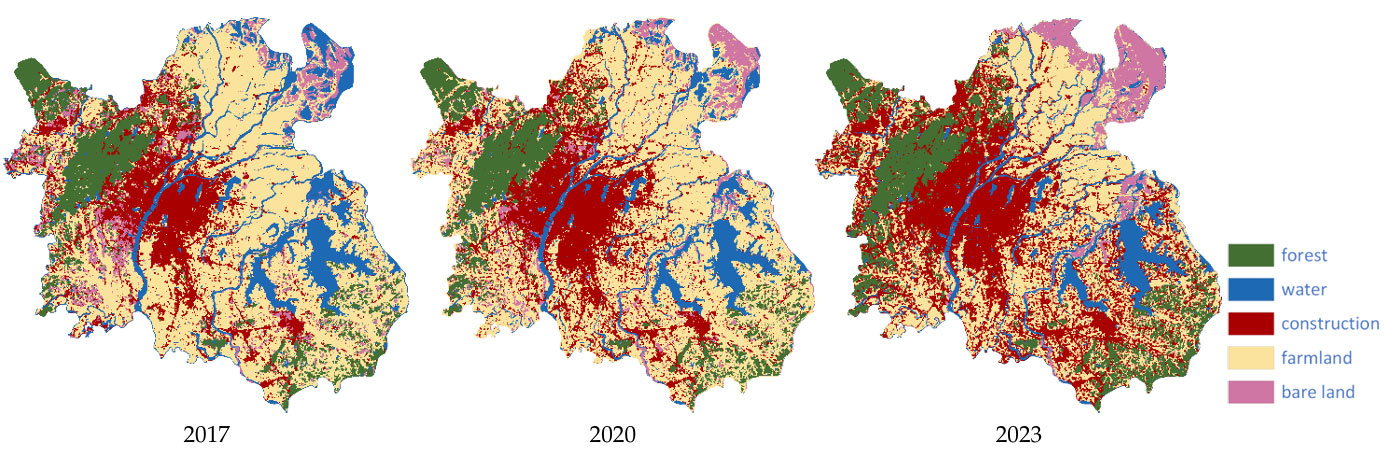
The planning of metropolises is a challenging issue, as it guides the high-quality development of developing cities. Providing a development direction through rational planning while avoiding path dependency is a key challenge for developing cities pursuing high-quality development. This issue is discussed in this paper, with the Nanchang Metropolitan Area, China, taken as an example. The solution involves analyzing the urban spatial pattern to reveal the phased characteristics and evolutionary trajectory of the urbanization process, and comparing it with developed cities to provide insights. To this end, satellite remote sensing data and landscape indices are used for the analysis. Data sources are provided by tasks such as satellite image classification at different scales, post-processing of unsupervised segmentation, and statistics of landscape metrics. The research analyzes the current status and changes of Nanchang's spatial pattern from 2017 to 2023, and conducts a comparison with the Sydney Metropolitan Area to explore the future development direction of Nanchang. This provides insights for understanding the current spatial pattern of developing cities and determining their development directions.
Graphical Abstract
Keywords
Data Availability Statement
Funding
Conflicts of Interest
AI Use Statement
Ethical Approval and Consent to Participate
References
- Cattivelli, V. (2021). Methods for the identification of urban, rural and peri-urban areas in Europe: An overview. Journal of Urban Regeneration and Renewal, 14(3), 240-246.
[CrossRef] [Google Scholar] - Statistics Bureau of Nanchang. (2023). Bulletin on major data of the permanent population of Nanchang City in 2022. Retrieved from http://tjj.nc.gov.cn/ncstjj/tjgb/202303/7278c6e7d677490f91904485ce15450a.shtml
[Google Scholar] - Ma, Y., Deng, X., & Wei, J. (2023). Land Use Classification of High-Resolution Multispectral Satellite Images With Fine-Grained Multiscale Networks and Superpixel Postprocessing. IEEE Journal of Selected Topics in Applied Earth Observations and Remote Sensing, 16, 3264-3278.
[CrossRef] [Google Scholar] - Long, J., Li, M., Wang, X., & Stein, A. (2022). Delineation of agricultural fields using multi-task BsiNet from high-resolution satellite images. International Journal of Applied Earth Observation and Geoinformation, 112, 102871.
[CrossRef] [Google Scholar] - Tong, X. Y., Xia, G. S., Lu, Q., Shen, H., Li, S., You, S., & Zhang, L. (2020). Land-cover classification with high-resolution remote sensing images using transferable deep models. Remote Sensing of Environment, 237, 111322.
[CrossRef] [Google Scholar] - Kirillov, A., Mintun, E., Ravi, N., Mao, H., Rolland, C., Gustafson, L., ... & Girshick, R. (2023, October). Segment Anything. In 2023 IEEE/CVF International Conference on Computer Vision (ICCV) (pp. 3992-4003). IEEE.
[CrossRef] [Google Scholar] - Osco, L. P., Wu, Q., De Lemos, E. L., Gonçalves, W. N., Ramos, A. P. M., Li, J., & Junior, J. M. (2023). The segment anything model (sam) for remote sensing applications: From zero to one shot. International Journal of Applied Earth Observation and Geoinformation, 124, 103540.
[CrossRef] [Google Scholar] - Ren, S., Luzi, F., Lahrichi, S., Kassaw, K., Collins, L. M., Bradbury, K., & Malof, J. M. (2024, January). Segment anything, from space?. In 2024 IEEE/CVF Winter Conference on Applications of Computer Vision (WACV) (pp. 8340-8350). IEEE.
[CrossRef] [Google Scholar]
Cite This Article
TY  - JOUR
AU  - Zhou, Chenghao
AU  - Li, Chunren
AU  - Wei, Jingbo
PY  - 2026
DA  - 2026/04/17
TI  - Analysis of Urban Spatial Patterns Based on Satellite Remote Sensing and Comparison between Metropolitans - A Case Study of Nanchang, China
JO  - Journal of Geoscience and Earth Observation
T2  - Journal of Geoscience and Earth Observation
JF  - Journal of Geoscience and Earth Observation
VL  - 1
IS  - 1
SP  - 55
EP  - 68
DO  - 10.62762/JGEO.2025.550212
UR  - https://www.icck.org/article/abs/JGEO.2025.550212
KW  - remote sensing
KW  - urban spatial pattern
KW  - classification
KW  - segmentation
KW  - landscape indicators
KW  - Nanchang
KW  - Sydney
AB  - The planning of metropolises is a challenging issue, as it guides the high-quality development of developing cities. Providing a development direction through rational planning while avoiding path dependency is a key challenge for developing cities pursuing high-quality development. This issue is discussed in this paper, with the Nanchang Metropolitan Area, China, taken as an example. The solution involves analyzing the urban spatial pattern to reveal the phased characteristics and evolutionary trajectory of the urbanization process, and comparing it with developed cities to provide insights. To this end, satellite remote sensing data and landscape indices are used for the analysis. Data sources are provided by tasks such as satellite image classification at different scales, post-processing of unsupervised segmentation, and statistics of landscape metrics. The research analyzes the current status and changes of Nanchang's spatial pattern from 2017 to 2023, and conducts a comparison with the Sydney Metropolitan Area to explore the future development direction of Nanchang. This provides insights for understanding the current spatial pattern of developing cities and determining their development directions.
SN  - pending
PB  - Institute of Central Computation and Knowledge
LA  - English
ER  -
@article{Zhou2026Analysis,
  author = {Chenghao Zhou and Chunren Li and Jingbo Wei},
  title = {Analysis of Urban Spatial Patterns Based on Satellite Remote Sensing and Comparison between Metropolitans - A Case Study of Nanchang, China},
  journal = {Journal of Geoscience and Earth Observation},
  year = {2026},
  volume = {1},
  number = {1},
  pages = {55-68},
  doi = {10.62762/JGEO.2025.550212},
  url = {https://www.icck.org/article/abs/JGEO.2025.550212},
  abstract = {The planning of metropolises is a challenging issue, as it guides the high-quality development of developing cities. Providing a development direction through rational planning while avoiding path dependency is a key challenge for developing cities pursuing high-quality development. This issue is discussed in this paper, with the Nanchang Metropolitan Area, China, taken as an example. The solution involves analyzing the urban spatial pattern to reveal the phased characteristics and evolutionary trajectory of the urbanization process, and comparing it with developed cities to provide insights. To this end, satellite remote sensing data and landscape indices are used for the analysis. Data sources are provided by tasks such as satellite image classification at different scales, post-processing of unsupervised segmentation, and statistics of landscape metrics. The research analyzes the current status and changes of Nanchang's spatial pattern from 2017 to 2023, and conducts a comparison with the Sydney Metropolitan Area to explore the future development direction of Nanchang. This provides insights for understanding the current spatial pattern of developing cities and determining their development directions.},
  keywords = {remote sensing, urban spatial pattern, classification, segmentation, landscape indicators, Nanchang, Sydney},
  issn = {pending},
  publisher = {Institute of Central Computation and Knowledge}
}
Article Metrics
Publisher's Note
ICCK stays neutral with regard to jurisdictional claims in published maps and institutional affiliations.
Rights and Permissions
 Copyright © 2026 by the Author(s). Published by Institute of Central Computation and Knowledge. This article is an open access article distributed under the terms and conditions of the Creative Commons Attribution (CC BY) license (https://creativecommons.org/licenses/by/4.0/), which permits use, sharing, adaptation, distribution and reproduction in any medium or format, as long as you give appropriate credit to the original author(s) and the source, provide a link to the Creative Commons licence, and indicate if changes were made.

Portico
