

How Much Does the Classifier Matter? A Cluster-Aware Comparison of Six Machine Learning Algorithms for Land Use Land Cover Mapping of Taipei, Taiwan, Using Google Earth Engine and Python



Article Information
Abstract
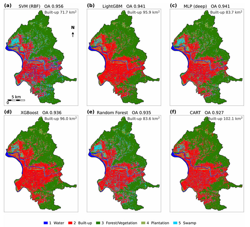
Comparative studies of machine learning classifiers for Land Use Land Cover (LULC) mapping often recommend one algorithm, yet their validation pixels are usually drawn from a few hand-digitised polygons and are far from independent. This study tested whether such differences survive that dependence. Six classifiers, namely Classification and Regression Tree (CART), Random Forest, Extreme Gradient Boosting (XGBoost), Light Gradient Boosting Machine (LightGBM), a multilayer perceptron and a support vector machine (SVM) with a radial basis function kernel, were applied to four top-of-atmosphere bands of a 2020 annual Sentinel-2 median composite of Taipei City, Taiwan, at 10~m. All 110 reference polygons were kept whole in both the hold-out split and the tuning folds. Pairwise differences were tested with the standard and the cluster-corrected McNemar test, and accuracies and class areas were estimated with the Olofsson stratified estimator on the effective sample size. Hold-out overall accuracy ranged only from 0.927 (CART) to 0.956 (SVM). The 1,829 validation pixels came from 30 polygons and, with a design effect of 71-76, were equivalent to only 24-26 independent observations. Eight of the fifteen pairwise differences were significant under the standard test, but none remained significant after the cluster correction. Mapped areas nevertheless differed markedly between models, from 71.7 to 102.1~km$^2$ for built-up land and from 10.9 to 32.2~km$^2$ for swamp; for built-up land, the between-model spread was as large as the sampling uncertainty of a single map. The six classifiers are therefore statistically indistinguishable in accuracy, and the choice among them should rest on computational cost, which differed by a factor of about 330 at inference, and on the stability of the areas they produce.
Graphical Abstract
Keywords
Data Availability Statement
Funding
Conflicts of Interest
AI Use Statement
Ethical Approval and Consent to Participate
References
- Foley, J. A., DeFries, R., Asner, G. P., Barford, C., Bonan, G., Carpenter, S. R., ... & Snyder, P. K. (2005). Global consequences of land use. science, 309(5734), 570-574.
[CrossRef] [Google Scholar] - Mishra, V. N., Prasad, R., Rai, P. K., Vishwakarma, A. K., & Arora, A. (2019). Performance evaluation of textural features in improving land use/land cover classification accuracy of heterogeneous landscape using multi-sensor remote sensing data. Earth Science Informatics, 12(1), 71-86.
[CrossRef] [Google Scholar] - Zhao, Z., Islam, F., Waseem, L. A., Tariq, A., Nawaz, M., Islam, I. U., ... & Hatamleh, W. A. (2024). Comparison of three machine learning algorithms using google earth engine for land use land cover classification. Rangeland ecology & management, 92, 129-137.
[CrossRef] [Google Scholar] - Ouchra, H., Belangour, A., Erraissi, A., & Banane, M. (2023, September). Assessing machine learning algorithms for land use and land cover classification in Morocco using google earth engine. In International Conference on Image Analysis and Processing (pp. 395-405). Cham: Springer Nature Switzerland.
[CrossRef] [Google Scholar] - Gorelick, N., Hancher, M., Dixon, M., Ilyushchenko, S., Thau, D., & Moore, R. (2017). Google Earth Engine: Planetary-scale geospatial analysis for everyone. Remote sensing of Environment, 202, 18-27.
[CrossRef] [Google Scholar] - Gumma, M. K., Thenkabail, P. S., Teluguntla, P. G., Oliphant, A., Xiong, J., Giri, C., ... & Whitbread, A. M. (2020). Agricultural cropland extent and areas of South Asia derived using Landsat satellite 30-m time-series big-data using random forest machine learning algorithms on the Google Earth Engine cloud. GIScience & Remote Sensing, 57(3), 302-322.
[CrossRef] [Google Scholar] - Pande, C. B. (2022). Land use/land cover and change detection mapping in Rahuri watershed area (MS), India using the google earth engine and machine learning approach. Geocarto International, 37(26), 13860-13880.
[CrossRef] [Google Scholar] - Feizizadeh, B., Omarzadeh, D., Kazemi Garajeh, M., Lakes, T., & Blaschke, T. (2023). Machine learning data-driven approaches for land use/cover mapping and trend analysis using Google Earth Engine. Journal of Environmental Planning and Management, 66(3), 665-697.
[CrossRef] [Google Scholar] - Shao, Y., & Lunetta, R. S. (2012). Comparison of support vector machine, neural network, and CART algorithms for the land-cover classification using limited training data points. ISPRS Journal of Photogrammetry and Remote Sensing, 70, 78-87.
[CrossRef] [Google Scholar] - Qian, Y., Zhou, W., Yan, J., Li, W., & Han, L. (2014). Comparing machine learning classifiers for object-based land cover classification using very high resolution imagery. Remote sensing, 7(1), 153-168.
[CrossRef] [Google Scholar] - Rodriguez-Galiano, V. F., Ghimire, B., Rogan, J., Chica-Olmo, M., & Rigol-Sanchez, J. P. (2012). An assessment of the effectiveness of a random forest classifier for land-cover classification. ISPRS journal of photogrammetry and remote sensing, 67, 93-104.
[CrossRef] [Google Scholar] - Ghosh, A., Sharma, R., & Joshi, P. K. (2014). Random forest classification of urban landscape using Landsat archive and ancillary data: Combining seasonal maps with decision level fusion. Applied Geography, 48, 31-41.
[CrossRef] [Google Scholar] - Arpitha, M., Ahmed, S.A., & Harishnaika, N. (2023). Land use and land cover classification using machine learning algorithms in Google Earth Engine. Earth Science Informatics, 16(4), 3057-3073.
[CrossRef] [Google Scholar] - Talukdar, S., Singha, P., Mahato, S., Pal, S., Liou, Y. A., & Rahman, A. (2020). Land-use land-cover classification by machine learning classifiers for satellite observations—A review. Remote sensing, 12(7), 1135.
[CrossRef] [Google Scholar] - Camargo, F. F., Sano, E. E., Almeida, C. M., Mura, J. C., & Almeida, T. (2019). A comparative assessment of machine-learning techniques for land use and land cover classification of the Brazilian tropical savanna using ALOS-2/PALSAR-2 polarimetric images. Remote Sensing, 11(13), 1600.
[CrossRef] [Google Scholar] - Roberts, D. R., Bahn, V., Ciuti, S., Boyce, M. S., Elith, J., Guillera‐Arroita, G., ... & Dormann, C. F. (2017). Cross‐validation strategies for data with temporal, spatial, hierarchical, or phylogenetic structure. Ecography, 40(8), 913-929.
[CrossRef] [Google Scholar] - Ploton, P., Mortier, F., Réjou-Méchain, M., Barbier, N., Picard, N., Rossi, V., ... & Pélissier, R. (2020). Spatial validation reveals poor predictive performance of large-scale ecological mapping models. Nature communications, 11(1), 4540.
[CrossRef] [Google Scholar] - Meyer, H., & Pebesma, E. (2022). Machine learning-based global maps of ecological variables and the challenge of assessing them. Nature Communications, 13(1), 2208.
[CrossRef] [Google Scholar] - Kish, L. (1965). Survey Sampling. John Wiley & Sons, New York.
[CrossRef] [Google Scholar] - Foody, G. M. (2004). Thematic map comparison. Photogrammetric Engineering & Remote Sensing, 70(5), 627-633.
[CrossRef] [Google Scholar] - Durkalski, V. L., Palesch, Y. Y., Lipsitz, S. R., & Rust, P. F. (2003). Analysis of clustered matched‐pair data. Statistics in medicine, 22(15), 2417-2428.
[CrossRef] [Google Scholar] - Jen-Chieh, C., & Yu-i, L. (2013, August). Using Formosat-2 Satellite Images to Manage Hillside Land Cover Change in Taipei City. In 2013 the International Conference on Remote Sensing, Environment and Transportation Engineering (RSETE 2013) (pp. 849-852). Atlantis Press.
[CrossRef] [Google Scholar] - Liu, C.-Y. & Arora, A. (2024). Decadal analysis and simulation of land use and land cover changes in Taiwan using machine learning and Markov chain models. Environment, Development and Sustainability, 28, 22577-22613.
[CrossRef] [Google Scholar] - Chen, Y. Y., Huang, W., Wang, W. H., Juang, J. Y., Hong, J. S., Kato, T., & Luyssaert, S. (2019). Reconstructing Taiwan's land cover changes between 1904 and 2015 from historical maps and satellite images. Scientific reports, 9(1), 3643.
[CrossRef] [Google Scholar] - Breiman, L., Friedman, J.H., Olshen, R.A., & Stone, C.J. (1984). Classification and Regression Trees. Wadsworth, Belmont, CA.
[CrossRef] [Google Scholar] - Breiman, L. (2001). Random forests. Machine Learning, 45, 5-32.
[CrossRef] [Google Scholar] - Pal, M. (2005). Random forest classifier for remote sensing classification. International journal of remote sensing, 26(1), 217-222.
[CrossRef] [Google Scholar] - Chen, T. & Guestrin, C. (2016). XGBoost: a scalable tree boosting system. In Proceedings of the 22nd ACM SIGKDD International Conference on Knowledge Discovery and Data Mining, 785-794.
[CrossRef] [Google Scholar] - Ke, G., Meng, Q., Finley, T., Wang, T., Chen, W., Ma, W., Ye, Q., & Liu, T.-Y. (2017). LightGBM: a highly efficient gradient boosting decision tree. In Advances in Neural Information Processing Systems, 30, 3146-3154.
[Google Scholar] - Cortes, C. & Vapnik, V. (1995). Support-vector networks. Machine Learning, 20(3), 273-297.
[CrossRef] [Google Scholar] - Mountrakis, G., Im, J., & Ogole, C. (2011). Support vector machines in remote sensing: A review. ISPRS journal of photogrammetry and remote sensing, 66(3), 247-259.
[CrossRef] [Google Scholar] - Hsu, C.-W., Chang, C.-C., & Lin, C.-J. (2003). A Practical Guide to Support Vector Classification. Technical Report, Department of Computer Science, National Taiwan University, Taipei. https://www.csie.ntu.edu.tw/~cjlin/papers/guide/guide.pdf
[Google Scholar] - Martins, S., Bernardo, N., Ogashawara, I., & Alcantara, E. (2016). Support vector machine algorithm optimal parameterization for change detection mapping in Funil Hydroelectric Reservoir (Rio de Janeiro State, Brazil). Modeling Earth Systems and Environment, 2(3), 138.
[CrossRef] [Google Scholar] - Cohen, J. (1960). A coefficient of agreement for nominal scales. Educational and psychological measurement, 20(1), 37-46.
[CrossRef] [Google Scholar] - Olofsson, P., Foody, G. M., Herold, M., Stehman, S. V., Woodcock, C. E., & Wulder, M. A. (2014). Good practices for estimating area and assessing accuracy of land change. Remote sensing of Environment, 148, 42-57.
[CrossRef] [Google Scholar] - Stehman, S. V. (2014). Estimating area and map accuracy for stratified random sampling when the strata are different from the map classes. International journal of remote sensing, 35(13), 4923-4939.
[CrossRef] [Google Scholar] - Holm, S. (1979). A simple sequentially rejective multiple test procedure. Scandinavian Journal of Statistics, 6(2), 65-70. https://www.ime.usp.br/~abe/lista/pdf4R8xPVzCnX.pdf
[Google Scholar] - Tayyebi, A., & Pijanowski, B. C. (2014). Modeling multiple land use changes using ANN, CART and MARS: Comparing tradeoffs in goodness of fit and explanatory power of data mining tools. International journal of applied earth observation and geoinformation, 28, 102-116.
[CrossRef] [Google Scholar] - Nigar, A., Li, Y., Jat Baloch, M. Y., Alrefaei, A. F., & Almutairi, M. H. (2024). Comparison of machine and deep learning algorithms using Google Earth Engine and Python for land classifications. Frontiers in Environmental Science, 12, 1378443.
[CrossRef] [Google Scholar] - Zha, Y., Gao, J., & Ni, S. (2003). Use of normalized difference built-up index in automatically mapping urban areas from TM imagery. International journal of remote sensing, 24(3), 583-594.
[CrossRef] [Google Scholar]
Cite This Article
TY  - JOUR
AU  - Liu, Chun-ya
PY  - 2026
DA  - 2026/10/26
TI  - How Much Does the Classifier Matter? A Cluster-Aware Comparison of Six Machine Learning Algorithms for Land Use Land Cover Mapping of Taipei, Taiwan, Using Google Earth Engine and Python
JO  - ICCK Journal of Image Analysis and Processing
T2  - ICCK Journal of Image Analysis and Processing
JF  - ICCK Journal of Image Analysis and Processing
VL  - 2
IS  - 4
SP  - 252
EP  - 276
DO  - 10.62762/JIAP.2026.490298
UR  - https://www.icck.org/article/abs/JIAP.2026.490298
KW  - land use land cover
KW  - google earth engine
KW  - sentinel-2
KW  - spatial autocorrelation
KW  - clustered McNemar test
KW  - design effect
KW  - area estimation
KW  - Taipei
AB  - Comparative studies of machine learning classifiers for Land Use Land Cover (LULC) mapping often recommend one algorithm, yet their validation pixels are usually drawn from a few hand-digitised polygons and are far from independent. This study tested whether such differences survive that dependence. Six classifiers, namely Classification and Regression Tree (CART), Random Forest, Extreme Gradient Boosting (XGBoost), Light Gradient Boosting Machine (LightGBM), a multilayer perceptron and a support vector machine (SVM) with a radial basis function kernel, were applied to four top-of-atmosphere bands of a 2020 annual Sentinel-2 median composite of Taipei City, Taiwan, at 10~m. All 110 reference polygons were kept whole in both the hold-out split and the tuning folds. Pairwise differences were tested with the standard and the cluster-corrected McNemar test, and accuracies and class areas were estimated with the Olofsson stratified estimator on the effective sample size. Hold-out overall accuracy ranged only from 0.927 (CART) to 0.956 (SVM). The 1,829 validation pixels came from 30 polygons and, with a design effect of 71-76, were equivalent to only 24-26 independent observations. Eight of the fifteen pairwise differences were significant under the standard test, but none remained significant after the cluster correction. Mapped areas nevertheless differed markedly between models, from 71.7 to 102.1~km$^2$ for built-up land and from 10.9 to 32.2~km$^2$ for swamp; for built-up land, the between-model spread was as large as the sampling uncertainty of a single map. The six classifiers are therefore statistically indistinguishable in accuracy, and the choice among them should rest on computational cost, which differed by a factor of about 330 at inference, and on the stability of the areas they produce.
SN  - 3068-6679
PB  - Institute of Central Computation and Knowledge
LA  - English
ER  -
@article{Liu2026How,
  author = {Chun-ya Liu},
  title = {How Much Does the Classifier Matter? A Cluster-Aware Comparison of Six Machine Learning Algorithms for Land Use Land Cover Mapping of Taipei, Taiwan, Using Google Earth Engine and Python},
  journal = {ICCK Journal of Image Analysis and Processing},
  year = {2026},
  volume = {2},
  number = {4},
  pages = {252-276},
  doi = {10.62762/JIAP.2026.490298},
  url = {https://www.icck.org/article/abs/JIAP.2026.490298},
  abstract = {Comparative studies of machine learning classifiers for Land Use Land Cover (LULC) mapping often recommend one algorithm, yet their validation pixels are usually drawn from a few hand-digitised polygons and are far from independent. This study tested whether such differences survive that dependence. Six classifiers, namely Classification and Regression Tree (CART), Random Forest, Extreme Gradient Boosting (XGBoost), Light Gradient Boosting Machine (LightGBM), a multilayer perceptron and a support vector machine (SVM) with a radial basis function kernel, were applied to four top-of-atmosphere bands of a 2020 annual Sentinel-2 median composite of Taipei City, Taiwan, at 10~m. All 110 reference polygons were kept whole in both the hold-out split and the tuning folds. Pairwise differences were tested with the standard and the cluster-corrected McNemar test, and accuracies and class areas were estimated with the Olofsson stratified estimator on the effective sample size. Hold-out overall accuracy ranged only from 0.927 (CART) to 0.956 (SVM). The 1,829 validation pixels came from 30 polygons and, with a design effect of 71-76, were equivalent to only 24-26 independent observations. Eight of the fifteen pairwise differences were significant under the standard test, but none remained significant after the cluster correction. Mapped areas nevertheless differed markedly between models, from 71.7 to 102.1~km\$^2\$ for built-up land and from 10.9 to 32.2~km\$^2\$ for swamp; for built-up land, the between-model spread was as large as the sampling uncertainty of a single map. The six classifiers are therefore statistically indistinguishable in accuracy, and the choice among them should rest on computational cost, which differed by a factor of about 330 at inference, and on the stability of the areas they produce.},
  keywords = {land use land cover, google earth engine, sentinel-2, spatial autocorrelation, clustered McNemar test, design effect, area estimation, Taipei},
  issn = {3068-6679},
  publisher = {Institute of Central Computation and Knowledge}
}
Article Metrics
Publisher's Note
ICCK stays neutral with regard to jurisdictional claims in published maps and institutional affiliations.
Rights and Permissions
 Copyright © 2026 by the Author(s). Published by Institute of Central Computation and Knowledge. This article is an open access article distributed under the terms and conditions of the Creative Commons Attribution (CC BY) license (https://creativecommons.org/licenses/by/4.0/), which permits use, sharing, adaptation, distribution and reproduction in any medium or format, as long as you give appropriate credit to the original author(s) and the source, provide a link to the Creative Commons licence, and indicate if changes were made.


Portico
