Spatiotemporal Assessment of Desertification Sensitivity in Ningxia, China, Using the MEDALUS Framework and Random Forest Classification (2001–2022)

Article Information
Abstract
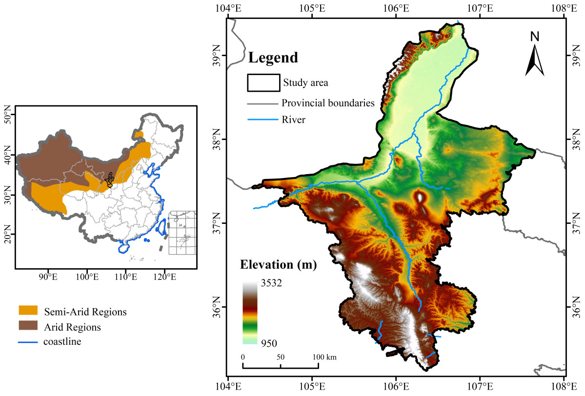
In semi-arid regions, desertification is a critical environmental degradation factor. This study analyzes land degradation and desertification vulnerability dynamics in Ningxia, China (2001–2022) using the MEDALUS framework with a Random Forest classifier. Land-cover change was significant due to irrigation and agricultural expansion, with farmland increasing to 65.29% of the landscape while grassland shrank to 10.13%, intensifying ecological pressure. Bare land followed a U-shaped trend, reaching 9.17% in 2022, indicating increased soil exposure. Soil quality remained moderately stable, with 70–80% of land retaining integrity despite ongoing degradation. Vegetation quality fluctuated considerably, as poor vegetation quality decreased from 42.42% in 2001 to 36.6% in 2022, with scattered local recovery. Management quality improved due to irrigation modernization and policy implementation, while long-term aridity moderately constrained climatic conditions. The Desertification Sensitivity Index (DSI) varied over time: low-desertification areas accounted for 44.47% in 2001, while high-desertification areas comprised 29.06%. By 2011, conservation efforts increased stable areas to 48.26%. However, in 2022, high-desertification areas persisted across 9,552.49 km², primarily in northern and central regions characterized by poor soil and uneven rainfall. This research provides robust scientific evidence to inform land management, vegetation rehabilitation, and climate adaptation strategies in vulnerable drylands.
Graphical Abstract
Keywords
Data Availability Statement
Funding
Conflicts of Interest
AI Use Statement
Ethical Approval and Consent to Participate
References
- Safriel, U. N. (2007). The assessment of global trends in land degradation. In Climate and land degradation (pp. 1-38). Berlin, Heidelberg: Springer Berlin Heidelberg.
[CrossRef] [Google Scholar] - Ambalam, K. (2014). United nations convention to combat desertification: Issues and challenges. E-Int. Rel, 30.
[Google Scholar] - Karmaoui, A., El Jaafari, S., Chaachouay, H., & Hajji, L. (2022). The socio-ecological system of the pre-Sahara zone of Morocco: a conceptual framework to analyse the impact of drought and desertification. GeoJournal, 87(6), 4961-4974.
[CrossRef] [Google Scholar] - Reynolds, J. F., Smith, D. M. S., Lambin, E. F., Turner, B. L., Mortimore, M., Batterbury, S. P., ... & Walker, B. (2007). Global desertification: building a science for dryland development. science, 316(5826), 847-851.
[CrossRef] [Google Scholar] - Kairis, O., Karavitis, C., Salvati, L., Kounalaki, A., & Kosmas, K. (2015). Exploring the impact of overgrazing on soil erosion and land degradation in a dry Mediterranean agro-forest landscape (Crete, Greece). Arid land research and management, 29(3), 360-374.
[CrossRef] [Google Scholar] - Kosmas, C., Ferrara, A. M. S., Briasouli, H., & Imeson, A. (1999). Methodology for mapping environmentally sensitive areas (ESAs) to desertification. In 'The Medalus project Mediterranean desertification and land use. Manual on key indicators of desertification and mapping environmentally sensitive areas to desertification (pp. 31-47). European Commission.
[Google Scholar] - De Paola, F., Ducci, D., & Giugni, M. (2013). Desertification and erosion sensitivity. A case study in southern Italy: the Tusciano River catchment. Environmental earth sciences, 70(5), 2179-2190.
[CrossRef] [Google Scholar] - Morianou, G., Kourgialas, N. N., Pisinaras, V., Psarras, G., & Arambatzis, G. (2021). Assessing desertification sensitivity map under climate change and agricultural practices scenarios: the island of Crete case study. Water Supply, 21(6), 2916-2934.
[CrossRef] [Google Scholar] - Bajocco, S., De Angelis, A., Perini, L., Ferrara, A., & Salvati, L. (2012). The impact of land use/land cover changes on land degradation dynamics: a Mediterranean case study. Environmental management, 49(5), 980-989.
[CrossRef] [Google Scholar] - Ladisa, G., Todorovic, M., & Liuzzi, G. T. (2012). A GIS-based approach for desertification risk assessment in Apulia region, SE Italy. Physics and Chemistry of the Earth, Parts a/B/C, 49, 103-113.
[CrossRef] [Google Scholar] - Rivera-Marin, D., Dash, J., & Ogutu, B. (2022). The use of remote sensing for desertification studies: A review. Journal of Arid Environments, 206, 104829.
[CrossRef] [Google Scholar] - Abuzaid, A. S., & Abdelatif, A. D. (2022). Assessment of desertification using modified MEDALUS model in the north Nile Delta, Egypt. Geoderma, 405, 115400.
[CrossRef] [Google Scholar] - Khaldi, Z., Weng, J., Antezana Lopez, F. P., Zhou, G., Ghedjatti, I., & Ali, A. (2025). PyGEE-ST-MEDALUS: AI Spatiotemporal Framework Integrating MODIS and Sentinel-1/-2 Data for Desertification Risk Assessment in Northeastern Algeria. Remote Sensing, 17(19), 3350.
[CrossRef] [Google Scholar] - Belgiu, M., & Drăguţ, L. (2016). Random forest in remote sensing: A review of applications and future directions. ISPRS journal of photogrammetry and remote sensing, 114, 24-31.
[CrossRef] [Google Scholar] - Shah, A. A., & Iqbal, M. F. (2024, December). Flood Susceptibility Mapping in District Jhang Using Remote Sensing and Advanced Machine Learning Techniques. In 2024 International Conference on Frontiers of Information Technology (FIT) (pp. 1-6). IEEE.
[CrossRef] [Google Scholar] - Ait Lamqadem, A., Pradhan, B., Saber, H., & Rahimi, A. (2018). Desertification sensitivity analysis using MEDALUS model and GIS: a case study of the Oases of Middle Draa Valley, Morocco. Sensors, 18(7), 2230.
[CrossRef] [Google Scholar] - Breiman, L. (2001). Random forests. Machine Learning, 45(1), 5–32.
[CrossRef] [Google Scholar] - Rodriguez-Galiano, V. F., Ghimire, B., Rogan, J., Chica-Olmo, M., & Rigol-Sanchez, J. P. (2012). An assessment of the effectiveness of a random forest classifier for land-cover classification. ISPRS journal of photogrammetry and remote sensing, 67, 93-104.
[CrossRef] [Google Scholar] - Al-Tameemi, N., Xuexia, Z., Shahzad, F., Mehmood, K., & Zhou, J. (2025). Enhancing desertification risk mapping with entropy-based weighting and machine learning: Insights from Iraq. Journal of Environmental Management, 396, 127976.
[CrossRef] [Google Scholar] - Wang, D., Hao, H., Liu, H., Sun, L., & Li, Y. (2024). Spatial–temporal changes of landscape and habitat quality in typical ecologically fragile areas of western China over the past 40 years: A case study of the Ningxia Hui Autonomous Region. Ecology and Evolution, 14(1), e10847.
[CrossRef] [Google Scholar] - Liu, Z., Sun, Q., Dai, P., Lei, J., Zeng, B., Wang, L., ... & Wang, J. (2023). An Analysis of the Spatiotemporal Variation in Wind Erosion–Climate Erosion Force in the Ningxia Region and Its Driving Factors. Atmosphere, 14(6), 963.
[CrossRef] [Google Scholar] - Li, W., Zhao, S., Chen, Y., Wang, Q., & Ai, W. (2021). State of China's climate in 2020. Atmospheric and Oceanic Science Letters, 14(4), 100048.
[CrossRef] [Google Scholar] - Forster, P. M., Smith, C. J., Walsh, T., Lamb, W. F., Lamboll, R., Hauser, M., ... & Zhai, P. (2023). Indicators of Global Climate Change 2022: annual update of large-scale indicators of the state of the climate system and human influence. Earth system science data, 15(6), 2295-2327.
[CrossRef] [Google Scholar] - Zhao, M., & Running, S. W. (2010). Drought-induced reduction in global terrestrial net primary production from 2000 through 2009. science, 329(5994), 940-943.
[CrossRef] [Google Scholar] - Li, R., Han, R., Yu, Q., Qi, S., & Guo, L. (2020). Spatial heterogeneous of ecological vulnerability in arid and semi-arid area: A case of the Ningxia Hui autonomous region, China. Sustainability, 12(11), 4401.
[CrossRef] [Google Scholar] - Huang, L., Xiao, T., Zhao, Z., Sun, C., Liu, J., Shao, Q., ... & Wang, J. (2013). Effects of grassland restoration programs on ecosystems in arid and semiarid China. Journal of Environmental Management, 117, 268-275.
[CrossRef] [Google Scholar] - Guo, X., & Shao, Q. (2019). Spatial pattern of soil erosion drivers and the contribution rate of human activities on the Loess Plateau from 2000 to 2015: A boundary line from northeast to southwest. Remote Sensing, 11(20), 2429.
[CrossRef] [Google Scholar] - Siyu, X., Zhixun, X., & Pingwu, W. (1996). Soil salinity in the irrigated area of the Yellow River in Ningxia, China. Arid Land Research and Management, 10(1), 95-101.
[CrossRef] [Google Scholar] - Mao, Z., Dong, B., & Pereira, L. S. (2004). Assessment and water saving issues for Ningxia paddies, upper Yellow River Basin. Paddy and Water Environment, 2(2), 99-110.
[CrossRef] [Google Scholar] - Yao, Y., Zheng, C., Tian, Y., Li, X., & Liu, J. (2018). Eco‐hydrological effects associated with environmental flow management: A case study from the arid desert region of China. Ecohydrology, 11(1), e1914.
[CrossRef] [Google Scholar] - Legg, S. (2021). IPCC, 2021: Climate change 2021-the physical science basis. Interaction, 49(4), 44-45.
[CrossRef] [Google Scholar] - Qi, L., Jiaqiang, L., Xiaosong, L., Youlin, Y. A. N. G., & Feng, W. A. N. G. (2020). China's combating desertification: national solutions and global paradigm. Bulletin of Chinese Academy of Sciences (Chinese Version), 35(6), 655-664.
[CrossRef] [Google Scholar] - Ogbue, C., Igboeli, E., Ajaero, C., Ochege, F. U., Yahaya, I. I., Yeneayehu, F., ... & Wang, Y. (2024). Remote sensing analysis of desert sensitive areas using MEDALUS model and GIS in the Niger River Basin. Ecological Indicators, 158, 111404.
[CrossRef] [Google Scholar] - Awais, M., Zaheen, Z., Fatima, Z., Shahwar, M., Jan, N., & Ali, S. (2024). Spatiotemporal drought assessment in Ningxia autonomous region: A machine learning and remote sensing approach. Asian Bull. Big Data Manage, 4(2), 1-16.
[CrossRef] [Google Scholar] - Lu, Q., Ma, H., Zhou, Y., Liu, J., & Shen, Y. (2023). Restoration of soil quality of degraded grassland can be accelerated by reseeding in an arid area of Northwest China. Frontiers in Plant Science, 14, 1101295.
[CrossRef] [Google Scholar] - Salmurzauly, R., Zulpykharov, K., Tokbergenova, A., Kaliyeva, D., & Bilalov, B. (2025). Ecological Vulnerability of Lands of Western Kazakhstan: Analysis Based on MEDALUS Model and Remote Sensing. Sustainability, 17(22), 9990.
[CrossRef] [Google Scholar] - Ferrara, A., Kosmas, C., Salvati, L., Padula, A., Mancino, G., & Nolè, A. (2020). Updating the MEDALUS‐ESA framework for worldwide land degradation and desertification assessment. Land Degradation & Development, 31(12), 1593-1607.
[CrossRef] [Google Scholar] - Jia, H., Tian, B., Song, X., Sun, W., & Mu, X. (2025). Hydrological shifts from vegetation restoration in semi-arid regions: insights from the typical watersheds of the Yellow River. Ecological Indicators, 178, 113924.
[CrossRef] [Google Scholar] - Liu, Q., Zhang, Q., Yan, Y., Zhang, X., Niu, J., & Svenning, J. C. (2020). Ecological restoration is the dominant driver of the recent reversal of desertification in the Mu Us Desert (China). Journal of Cleaner Production, 268, 122241.
[CrossRef] [Google Scholar] - Chen, Y., Ma, L., Wang, X., Liu, T., & Qiao, Z. (2025). Spatiotemporal patterns of desertification sensitivity and influencing factors across the Western Inner Mongolia Plateau, China. Ecological Informatics, 89, 103190.
[CrossRef] [Google Scholar] - ZhanNing, J., Liu, J., Kuang, W., Xu, X., Zhang, S., Yan, C., ... & Ning, J. (2018). Spatiotemporal patterns and characteristics of land-use change in China during 2010–2015. Journal of Geographical Sciences, 28(5), 547-562.
[CrossRef] [Google Scholar] - Li, J., Yang, X., Jin, Y., Yang, Z., Huang, W., Zhao, L., ... & Xu, B. (2013). Monitoring and analysis of grassland desertification dynamics using Landsat images in Ningxia, China. Remote Sensing of Environment, 138, 19-26.
[CrossRef] [Google Scholar] - Liu, H., Wang, H., Teng, Y., Zhan, J., Wang, C., Liu, W., ... & He, Y. (2024). Controlling desertification brings positive socioeconomic benefits beyond regional environmental improvement: Evidence from China's Gonghe Basin. Journal of Environmental Management, 354, 120395.
[CrossRef] [Google Scholar] - Zhao, X., Tan, Q., Wu, T., Cai, Y., & Sun, K. (2025). Detecting cropland abandonment and intentional afforestation using MODIS and landsat across agroclimatic zones. Ecological Informatics, 103512.
[CrossRef] [Google Scholar]
Cite This Article
TY  - JOUR
AU  - Nawaz, Munaza
AU  - Kalisa, Wilson
AU  - Zaheen, Zakria
AU  - Tauqir, Moughal
AU  - Zhang, Jiahua
AU  - Shah, Adnan Abbas
AU  - Ullah, Kalim
PY  - 2026
DA  - 2026/04/16
TI  - Spatiotemporal Assessment of Desertification Sensitivity in Ningxia, China, Using the MEDALUS Framework and Random Forest Classification (2001–2022)
JO  - Journal of Geoscience and Earth Observation
T2  - Journal of Geoscience and Earth Observation
JF  - Journal of Geoscience and Earth Observation
VL  - 1
IS  - 1
SP  - 39
EP  - 54
DO  - 10.62762/JGEO.2025.205415
UR  - https://www.icck.org/article/abs/JGEO.2025.205415
KW  - desertification
KW  - MEDALUS
KW  - random forest
KW  - Ningxia
KW  - land degradation
KW  - remote sensing
KW  - dryland ecosystems
KW  - google earth engine (GEE)
AB  - In semi-arid regions, desertification is a critical environmental degradation factor. This study analyzes land degradation and desertification vulnerability dynamics in Ningxia, China (2001–2022) using the MEDALUS framework with a Random Forest classifier. Land-cover change was significant due to irrigation and agricultural expansion, with farmland increasing to 65.29% of the landscape while grassland shrank to 10.13%, intensifying ecological pressure. Bare land followed a U-shaped trend, reaching 9.17% in 2022, indicating increased soil exposure. Soil quality remained moderately stable, with 70–80% of land retaining integrity despite ongoing degradation. Vegetation quality fluctuated considerably, as poor vegetation quality decreased from 42.42% in 2001 to 36.6% in 2022, with scattered local recovery. Management quality improved due to irrigation modernization and policy implementation, while long-term aridity moderately constrained climatic conditions. The Desertification Sensitivity Index (DSI) varied over time: low-desertification areas accounted for 44.47% in 2001, while high-desertification areas comprised 29.06%. By 2011, conservation efforts increased stable areas to 48.26%. However, in 2022, high-desertification areas persisted across 9,552.49 km², primarily in northern and central regions characterized by poor soil and uneven rainfall. This research provides robust scientific evidence to inform land management, vegetation rehabilitation, and climate adaptation strategies in vulnerable drylands.
SN  - pending
PB  - Institute of Central Computation and Knowledge
LA  - English
ER  -
@article{Nawaz2026Spatiotemp,
  author = {Munaza Nawaz and Wilson Kalisa and Zakria Zaheen and Moughal Tauqir and Jiahua Zhang and Adnan Abbas Shah and Kalim Ullah},
  title = {Spatiotemporal Assessment of Desertification Sensitivity in Ningxia, China, Using the MEDALUS Framework and Random Forest Classification (2001–2022)},
  journal = {Journal of Geoscience and Earth Observation},
  year = {2026},
  volume = {1},
  number = {1},
  pages = {39-54},
  doi = {10.62762/JGEO.2025.205415},
  url = {https://www.icck.org/article/abs/JGEO.2025.205415},
  abstract = {In semi-arid regions, desertification is a critical environmental degradation factor. This study analyzes land degradation and desertification vulnerability dynamics in Ningxia, China (2001–2022) using the MEDALUS framework with a Random Forest classifier. Land-cover change was significant due to irrigation and agricultural expansion, with farmland increasing to 65.29\% of the landscape while grassland shrank to 10.13\%, intensifying ecological pressure. Bare land followed a U-shaped trend, reaching 9.17\% in 2022, indicating increased soil exposure. Soil quality remained moderately stable, with 70–80\% of land retaining integrity despite ongoing degradation. Vegetation quality fluctuated considerably, as poor vegetation quality decreased from 42.42\% in 2001 to 36.6\% in 2022, with scattered local recovery. Management quality improved due to irrigation modernization and policy implementation, while long-term aridity moderately constrained climatic conditions. The Desertification Sensitivity Index (DSI) varied over time: low-desertification areas accounted for 44.47\% in 2001, while high-desertification areas comprised 29.06\%. By 2011, conservation efforts increased stable areas to 48.26\%. However, in 2022, high-desertification areas persisted across 9,552.49 km², primarily in northern and central regions characterized by poor soil and uneven rainfall. This research provides robust scientific evidence to inform land management, vegetation rehabilitation, and climate adaptation strategies in vulnerable drylands.},
  keywords = {desertification, MEDALUS, random forest, Ningxia, land degradation, remote sensing, dryland ecosystems, google earth engine (GEE)},
  issn = {pending},
  publisher = {Institute of Central Computation and Knowledge}
}
Article Metrics
Publisher's Note
ICCK stays neutral with regard to jurisdictional claims in published maps and institutional affiliations.
Rights and Permissions
 Copyright © 2026 by the Author(s). Published by Institute of Central Computation and Knowledge. This article is an open access article distributed under the terms and conditions of the Creative Commons Attribution (CC BY) license (https://creativecommons.org/licenses/by/4.0/), which permits use, sharing, adaptation, distribution and reproduction in any medium or format, as long as you give appropriate credit to the original author(s) and the source, provide a link to the Creative Commons licence, and indicate if changes were made.

Portico
