

Analysis of Bus Stop Infrastructure Using Deep Learning-Based Object Detection: A Case of Thrissur, Kerala, India



Article Information
Abstract
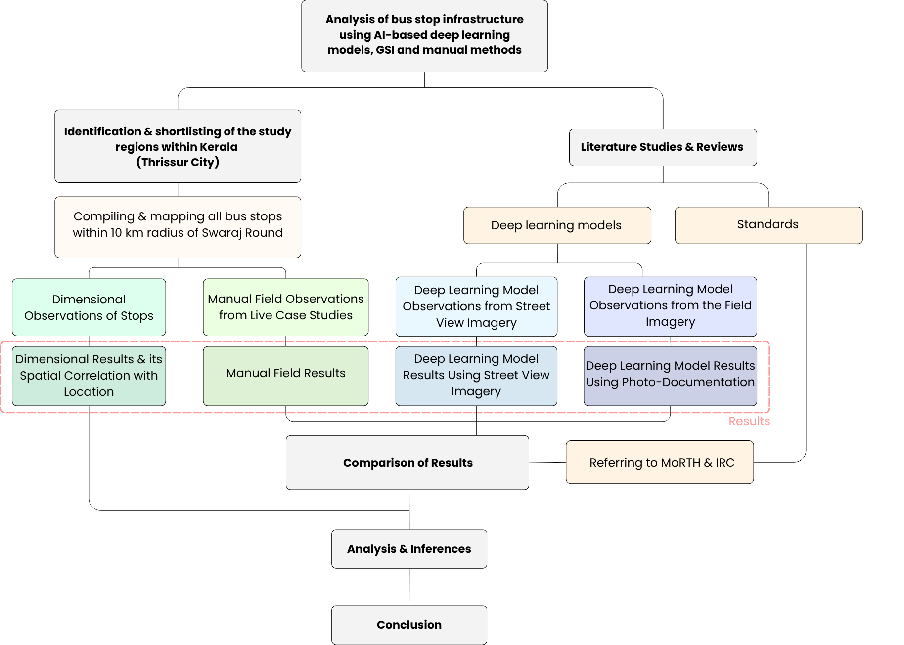
Bus transport forms the most critical and widely used component of the public road transportation system in India. Bus stops are therefore the most critical nodes connecting passengers to this system. Using a deep learning-based object detection model, this research provides a detailed analysis of the bus stop infrastructure in Thrissur, Kerala, India. The model is applied to a custom dataset of 400 field and Google Street View (GSV) images, and a comprehensive audit is conducted of 80 stops, benchmarking them against Indian road development standards. The findings reveal a large difference in time cost between the methods and demonstrate a highly reliable deep learning-based object detection system. In parallel, a `de facto' barrier is identified: a clear spatial inequality between the urban core and the periphery systematically excludes accessibility-dependent groups from safe and equitable access to public transport. Crucially, a `Modern but Inaccessible' paradox was observed: 100% of surveyed bus stops had roof shelters, yet only 2.5% complied with fundamental accessibility standards, a critical failure seen even in the newest structures. This study concludes that deep learning models such as YOLOv8 are among the most effective (recall of 75.3%, precision of 71.7%) and time-efficient (about 15 seconds to survey 80 bus stops after initial development) methods for large-scale urban infrastructural analysis.
Graphical Abstract
Keywords
Data Availability Statement
Funding
Conflicts of Interest
AI Use Statement
Ethical Approval and Consent to Participate
References
- Preston, J. (2020). Public transport. In International Encyclopedia of Human Geography (2nd ed., pp.\ 113-120). Elsevier.
[CrossRef] [Google Scholar] - Cambridge Dictionary. (n.d.). Retrieved April 12, 2026, from https://dictionary.cambridge.org/
[Google Scholar] - Kim, J., Park, J., Lee, J., & Jang, K.~M. (2024). Examining the socio-spatial patterns of bus shelters with deep learning analysis of street-view images: A case study of 20 cities in the U.S. Cities, 148, 104852.
[CrossRef] [Google Scholar] - Sijabat, K. R., Aufaristama, M., Wirawan Arief, M. C., & Dharmawan, I. A. (2025). Integrating remote sensing and street view imagery with deep learning for urban slum mapping: a case study from bandung city. Applied Sciences, 15(14), 8044.
[CrossRef] [Google Scholar] - Ashok Leyland. (n.d.). Viking VK2011.4T6R [Brochure]. Retrieved April 15, 2026, from https://www.scribd.com/document/516120834/AL-BS-VI-Viking-Brochure-R6-13-04-2020
[Google Scholar] - Tata Motors. (n.d.). Tata Starbus City [Specifications]. Retrieved April 15, 2026, from https://busesandvans.tatamotors.com/brand/starbus
[Google Scholar] - Volvo Buses. (n.d.). Volvo 8400 City Bus [Brochure]. Retrieved April 15, 2026, from https://www.volvobuses.com/in/news/2010/vbus-launches-new-avatar-of-city-bus.html
[Google Scholar] - State Planning Board, Government of Kerala. (2017). Economic Review 2017. Retrieved April 15, 2026, from https://spb.kerala.gov.in/economic-review/ER2017/web_e/index.php
[Google Scholar] - Briant, S., Cushing, D., Washington, T., & Swart, M. (2025). Small but significant: a review of research on the potential of bus shelters as resilient infrastructure. Applied Sciences, 15(12), 6724.
[CrossRef] [Google Scholar] - Ministry of Road Transport and Highways, Government of India. (2023). Ministry of Road Transport and Highways. Retrieved April 15, 2026, from https://morth.gov.in/
[Google Scholar] - Ministry of Road Transport and Highways. (2022). Accessibility guidelines for bus terminals and bus stops. Government of India. Retrieved April 15, 2026, from https://a11y.enabled.in/accessibility-guidelines-for-bus-terminals-bus-stops-morth/
[Google Scholar] - Indian Roads Congress. (2015). IRC 35: Code of practice for road markings (revised). New Delhi: IRC. Retrieved April 15, 2026, from https://archive.org/details/gov.in.irc.035.2015
[Google Scholar] - Indian Roads Congress. (1981). IRC 80: Type designs for pick-up bus stops on rural highways. New Delhi: IRC. Retrieved April 15, 2026, from https://archive.org/details/govlawircy1981sp80_0
[Google Scholar] - Indian Roads Congress. (2018). IRC SP 73: Manual of specifications and standards for two-laning of highways (revised). New Delhi: IRC. Retrieved April 15, 2026, from https://archive.org/details/gov.in.irc.sp.073.2018/irc.gov.in.sp.073.2018/
[Google Scholar] - Indian Roads Congress. (2019). IRC SP 84: Manual of specifications and standards for four-laning of highways (updated). New Delhi: IRC. Retrieved April 15, 2026, from https://archive.org/details/gov.in.irc.sp.084.2019
[Google Scholar] - Indian Roads Congress. (2012). IRC 103: Guidelines for pedestrian facilities. New Delhi: IRC. Retrieved April 15, 2026, from https://law.resource.org/pub/in/bis/irc/irc.gov.in.078.2.2020.pdf
[Google Scholar] - Samsung. (n.d.). Galaxy S22 Ultra-specifications. Retrieved April 20, 2026, from https://www.samsungmobilepress.com/media-assets/galaxy-s22-ultra
[Google Scholar] - Roboflow. (n.d.). Roboflow-Ultralytics integration. Retrieved April 16, 2026, from https://docs.ultralytics.com/integrations/roboflow
[Google Scholar] - Redmon, J., Divvala, S., Girshick, R., & Farhadi, A. (2016). You Only Look Once: Unified, real-time object detection. In Proceedings of the IEEE Conference on Computer Vision and Pattern Recognition (CVPR) (pp. 779-788).
[CrossRef] [Google Scholar] - Jocher, G., Chaurasia, A., & Qiu, J. (2023). Ultralytics YOLOv8. Retrieved April 16, 2026, from https://docs.ultralytics.com/models/yolov8
[Google Scholar] - Padilla, R., Passos, W. L., Dias, T. L., Netto, S. L., & Da Silva, E. A. (2021). A comparative analysis of object detection metrics with a companion open-source toolkit. Electronics, 10(3), 279.
[CrossRef] [Google Scholar] - McHugh, M.~L. (2012). Interrater reliability: The kappa statistic. Biochemia Medica, 22(3), 276-282.
[CrossRef] [Google Scholar] - Gwet, K.~L. (2008). Computing inter-rater reliability and its variance in the presence of high agreement. British Journal of Mathematical and Statistical Psychology, 61(1), 29-48.
[CrossRef] [Google Scholar] - Wongpakaran, N., Wongpakaran, T., Wedding, D., & Gwet, K.~L. (2013). A comparison of Cohen's kappa and Gwet's AC1 when calculating inter-rater reliability coefficients: A study conducted with personality disorder samples. BMC Medical Research Methodology, 13(1), 61.
[CrossRef] [Google Scholar] - Schindelin, J., Arganda-Carreras, I., Frise, E., Kaynig, V., Longair, M., Pietzsch, T., ... & Cardona, A. (2012). Fiji: an open-source platform for biological-image analysis. Nature methods, 9(7), 676-682.
[CrossRef] [Google Scholar] - Mamidi, R.~S., Kulkarni, B., & Singh, A. (2011). Secular trends in height in different states of India in relation to socioeconomic characteristics and dietary intakes. Food and Nutrition Bulletin, 32(1), 23-34.
[CrossRef] [Google Scholar]
Cite This Article
TY  - JOUR
AU  - Manoj, Arathy
AU  - Dev, Govind
PY  - 2026
DA  - 2026/09/09
TI  - Analysis of Bus Stop Infrastructure Using Deep Learning-Based Object Detection: A Case of Thrissur, Kerala, India
JO  - Sustainable Intelligent Infrastructure
T2  - Sustainable Intelligent Infrastructure
JF  - Sustainable Intelligent Infrastructure
VL  - 2
IS  - 2
SP  - 25
EP  - 35
DO  - 10.62762/SII.2026.715987
UR  - https://www.icck.org/article/abs/SII.2026.715987
KW  - bus stop infrastructure
KW  - deep learning
KW  - object detection
KW  - universal design
KW  - urban transportation
AB  - Bus transport forms the most critical and widely used component of the public road transportation system in India. Bus stops are therefore the most critical nodes connecting passengers to this system. Using a deep learning-based object detection model, this research provides a detailed analysis of the bus stop infrastructure in Thrissur, Kerala, India. The model is applied to a custom dataset of 400 field and Google Street View (GSV) images, and a comprehensive audit is conducted of 80 stops, benchmarking them against Indian road development standards. The findings reveal a large difference in time cost between the methods and demonstrate a highly reliable deep learning-based object detection system. In parallel, a `de facto' barrier is identified: a clear spatial inequality between the urban core and the periphery systematically excludes accessibility-dependent groups from safe and equitable access to public transport. Crucially, a `Modern but Inaccessible' paradox was observed: 100% of surveyed bus stops had roof shelters, yet only 2.5% complied with fundamental accessibility standards, a critical failure seen even in the newest structures. This study concludes that deep learning models such as YOLOv8 are among the most effective (recall of 75.3%, precision of 71.7%) and time-efficient (about 15 seconds to survey 80 bus stops after initial development) methods for large-scale urban infrastructural analysis.
SN  - 3067-8137
PB  - Institute of Central Computation and Knowledge
LA  - English
ER  -
@article{Manoj2026Analysis,
  author = {Arathy Manoj and Govind Dev},
  title = {Analysis of Bus Stop Infrastructure Using Deep Learning-Based Object Detection: A Case of Thrissur, Kerala, India},
  journal = {Sustainable Intelligent Infrastructure},
  year = {2026},
  volume = {2},
  number = {2},
  pages = {25-35},
  doi = {10.62762/SII.2026.715987},
  url = {https://www.icck.org/article/abs/SII.2026.715987},
  abstract = {Bus transport forms the most critical and widely used component of the public road transportation system in India. Bus stops are therefore the most critical nodes connecting passengers to this system. Using a deep learning-based object detection model, this research provides a detailed analysis of the bus stop infrastructure in Thrissur, Kerala, India. The model is applied to a custom dataset of 400 field and Google Street View (GSV) images, and a comprehensive audit is conducted of 80 stops, benchmarking them against Indian road development standards. The findings reveal a large difference in time cost between the methods and demonstrate a highly reliable deep learning-based object detection system. In parallel, a `de facto' barrier is identified: a clear spatial inequality between the urban core and the periphery systematically excludes accessibility-dependent groups from safe and equitable access to public transport. Crucially, a `Modern but Inaccessible' paradox was observed: 100\% of surveyed bus stops had roof shelters, yet only 2.5\% complied with fundamental accessibility standards, a critical failure seen even in the newest structures. This study concludes that deep learning models such as YOLOv8 are among the most effective (recall of 75.3\%, precision of 71.7\%) and time-efficient (about 15 seconds to survey 80 bus stops after initial development) methods for large-scale urban infrastructural analysis.},
  keywords = {bus stop infrastructure, deep learning, object detection, universal design, urban transportation},
  issn = {3067-8137},
  publisher = {Institute of Central Computation and Knowledge}
}
Article Metrics
Publisher's Note
ICCK stays neutral with regard to jurisdictional claims in published maps and institutional affiliations.
Rights and Permissions
 Copyright © 2026 by the Author(s). Published by Institute of Central Computation and Knowledge. This article is an open access article distributed under the terms and conditions of the Creative Commons Attribution (CC BY) license (https://creativecommons.org/licenses/by/4.0/), which permits use, sharing, adaptation, distribution and reproduction in any medium or format, as long as you give appropriate credit to the original author(s) and the source, provide a link to the Creative Commons licence, and indicate if changes were made.


Portico
