Volume 1, Issue 2, Digital Intelligence in Agriculture
Volume 1, Issue 2, 2025
Submit Manuscript Edit a Special Issue
Article QR Code
Article QR Code
Scan the QR code for reading
Popular articles
Digital Intelligence in Agriculture, Volume 1, Issue 2, 2025: 47-60

Open Access | Review Article | 06 November 2025
Global Research Trends on Ecosystem Service Valuation Using Remote Sensing (1990–2024)
1 Industry Development and Planning Institute, National Forestry and Grassland Administration, Beijing 100010, China
2 Shandong Institute of Territorial and Spatial Planning, Jinan 250014, China
3 Zhejiang Yuanzhuo Technology Co., Ltd., Hangzhou 310000, China
4 Fuyang Normal University, Fuyang 236037, China
* Corresponding Author: Sang Fu, [email protected]
ARK: ark:/57805/dia.2025.654827
Received: 23 September 2025, Accepted: 14 October 2025, Published: 06 November 2025  
Abstract
Ecosystem service valuation (ESV) provides a scientific basis for balancing ecological conservation and socioeconomic development. With the rapid progress of Earth observation technologies, remote sensing has become an essential tool for quantifying and mapping ecosystem services at multiple spatial and temporal scales. However, a comprehensive understanding of the global research landscape on ecosystem service valuation using remote sensing remains limited. In this study, this study conducted a bibliometric analysis of publications retrieved from the Web of Science Core Collection between 1990 and 2024. A total of 1172 articles were identified through a systematic search strategy integrating ecosystem service valuation and remote sensing keywords. The analysis employed performance indicators (e.g., publication output, citation trends, and core journals), collaboration networks (countries, institutions, and authors), and keyword co-occurrence to reveal research hotspots and emerging frontiers. The results show a steady growth of publications, with a significant surge after 2010 driven by the application of MODIS, Landsat, and Google Earth Engine in large-scale ESV studies. China, the United States, and several European countries play dominant roles in terms of both output and international collaboration. Research hotspots have shifted from conceptual frameworks and regional case studies to methodological innovations, such as spatial modeling, integration of remote sensing with ecosystem accounting frameworks, and applications in ecological security and sustainable development. This study highlights the increasing importance of remote sensing in advancing ecosystem service valuation and provides insights into future directions, including high-resolution monitoring, machine learning integration, and policy-oriented assessments.

Graphical Abstract
Global Research Trends on Ecosystem Service Valuation Using Remote Sensing (1990–2024)

Keywords
remote sensing
ecosystem service valuation
bibliometric analysis
natural capital accounting

Data Availability Statement
Data will be made available on request.

Funding
This work was supported in part by the Beijing Science and Technology Plan Project under Grant Z241100005424006; in part by the Development of Multi-Source Remote Sensing Data Coupling and Intelligent Recognition Technology; in part by the Key Project of the Talent Fund for Universities in Anhui Province under Grant gxgwfx2020003.

Conflicts of Interest
Chengyan Gu is an employee of Industry Development and Planning Institute, National Forestry and Grassland Administration, Beijing 100010, China; Zhihui Wang is an employee of Zhejiang Yuanzhuo Technology Co., Ltd., Hangzhou 310000, China. The authors declare no conflicts of interest.

Ethical Approval and Consent to Participate
Not applicable.

References
  1. Aria, M., & Cuccurullo, C. (2017). bibliometrix: An R-tool for comprehensive science mapping analysis. Journal of informetrics, 11(4), 959-975.
    [CrossRef]   [Google Scholar]
  2. Asner, G. P., Knapp, D. E., Boardman, J., Green, R. O., Kennedy-Bowdoin, T., Eastwood, M., ... & Field, C. B. (2012). Carnegie Airborne Observatory-2: Increasing science data dimensionality via high-fidelity multi-sensor fusion. Remote Sensing of Environment, 124, 454-465.
    [CrossRef]   [Google Scholar]
  3. Ayanu, Y. Z., Conrad, C., Nauss, T., Wegmann, M., & Koellner, T. (2012). Quantifying and mapping ecosystem services supplies and demands: a review of remote sensing applications. Environmental science & technology, 46(16), 8529-8541.
    [CrossRef]   [Google Scholar]
  4. Beale, C. M., & Lennon, J. J. (2012). Incorporating uncertainty in predictive species distribution modelling. Philosophical Transactions of the Royal Society B: Biological Sciences, 367(1586), 247-258.
    [CrossRef]   [Google Scholar]
  5. Börner, K., Chen, C., & Boyack, K. W. (2003). Visualizing knowledge domains. Annual review of information science and technology, 37(1), 179-255.
    [CrossRef]   [Google Scholar]
  6. Chen, C. (2017). Science mapping: a systematic review of the literature. Journal of data and information science, 2(2).
    [CrossRef]   [Google Scholar]
  7. Cord, A. F., Brauman, K. A., Chaplin-Kramer, R., Huth, A., Ziv, G., & Seppelt, R. (2017). Priorities to advance monitoring of ecosystem services using earth observation. Trends in ecology & evolution, 32(6), 416-428.
    [CrossRef]   [Google Scholar]
  8. Costanza, R., d'Arge, R., De Groot, R., Farber, S., Grasso, M., Hannon, B., ... & Van Den Belt, M. (1997). The value of the world's ecosystem services and natural capital. nature, 387(6630), 253-260.
    [CrossRef]   [Google Scholar]
  9. Daily, G. C., & Matson, P. A. (2008). Ecosystem services: From theory to implementation. Proceedings of the national academy of sciences, 105(28), 9455-9456.
    [CrossRef]   [Google Scholar]
  10. de Araujo Barbosa, C. C., Atkinson, P. M., & Dearing, J. A. (2015). Remote sensing of ecosystem services: A systematic review. Ecological indicators, 52, 430-443.
    [CrossRef]   [Google Scholar]
  11. Di Palma, M., Rigillo, M., & Leone, M. F. (2024). Remote sensing technologies for mapping ecosystem services: an analytical approach for urban green infrastructure. Sustainability, 16(14), 6220.
    [CrossRef]   [Google Scholar]
  12. Drusch, M., Del Bello, U., Carlier, S., Colin, O., Fernandez, V., Gascon, F., ... & Bargellini, P. (2012). Sentinel-2: ESA's optical high-resolution mission for GMES operational services. Remote sensing of Environment, 120, 25-36.
    [CrossRef]   [Google Scholar]
  13. Ferraro, P. J., & Hanauer, M. M. (2014). Advances in measuring the environmental and social impacts of environmental programs. Annual review of environment and resources, 39, 495-517.
    [CrossRef]   [Google Scholar]
  14. Fisher, B., Turner, R. K., & Morling, P. (2009). Defining and classifying ecosystem services for decision making. Ecological economics, 68(3), 643-653.
    [CrossRef]   [Google Scholar]
  15. Schägner, J. P., Brander, L., Maes, J., & Hartje, V. (2013). Mapping ecosystem services' values: Current practice and future prospects. Ecosystem services, 4, 33-46.
    [CrossRef]   [Google Scholar]
  16. Gomes, V. C., Queiroz, G. R., & Ferreira, K. R. (2020). An overview of platforms for big earth observation data management and analysis. Remote Sensing, 12(8), 1253.
    [CrossRef]   [Google Scholar]
  17. Gorelick, N., Hancher, M., Dixon, M., Ilyushchenko, S., Thau, D., & Moore, R. (2017). Google Earth Engine: Planetary-scale geospatial analysis for everyone. Remote sensing of Environment, 202, 18-27.
    [CrossRef]   [Google Scholar]
  18. Hein, L., Bagstad, K. J., Obst, C., Edens, B., Schenau, S., Castillo, G., ... & Caparrós, A. (2020). Progress in natural capital accounting for ecosystems. Science, 367(6477), 514-515.
    [CrossRef]   [Google Scholar]
  19. Huete, A., Didan, K., Miura, T., Rodriguez, E. P., Gao, X., & Ferreira, L. G. (2002). Overview of the radiometric and biophysical performance of the MODIS vegetation indices. Remote sensing of environment, 83(1-2), 195-213.
    [CrossRef]   [Google Scholar]
  20. Justice, C. O., Vermote, E., Townshend, J. R., Defries, R., Roy, D. P., Hall, D. K., ... & Barnsley, M. J. (1998). The Moderate Resolution Imaging Spectroradiometer (MODIS): Land remote sensing for global change research. IEEE transactions on geoscience and remote sensing, 36(4), 1228-1249.
    [CrossRef]   [Google Scholar]
  21. Kandziora, M., Burkhard, B., & Müller, F. (2013). Mapping provisioning ecosystem services at the local scale using data of varying spatial and temporal resolution. Ecosystem Services, 4, 47-59.
    [CrossRef]   [Google Scholar]
  22. Kumar, P. (2012). The economics of ecosystems and biodiversity: ecological and economic foundations. Routledge.
    [CrossRef]   [Google Scholar]
  23. Leydesdorff, L., & Vaughan, L. (2006). Co‐occurrence matrices and their applications in information science: Extending ACA to the Web environment. Journal of the American Society for Information Science and technology, 57(12), 1616-1628.
    [CrossRef]   [Google Scholar]
  24. Turner, W., Rondinini, C., Pettorelli, N., Mora, B., Leidner, A. K., Szantoi, Z., ... & Woodcock, C. (2015). Free and open-access satellite data are key to biodiversity conservation. Biological Conservation, 182, 173-176.
    [CrossRef]   [Google Scholar]
  25. Liquete, C., Piroddi, C., Drakou, E. G., Gurney, L., Katsanevakis, S., Charef, A., & Egoh, B. (2013). Current status and future prospects for the assessment of marine and coastal ecosystem services: a systematic review. PloS one, 8(7), e67737.
    [CrossRef]   [Google Scholar]
  26. Moher, D., Liberati, A., Tetzlaff, J., & Altman, D. G. (2009). Preferred reporting items for systematic reviews and meta-analyses: the PRISMA statement. Bmj, 339.
    [CrossRef]   [Google Scholar]
  27. Mongeon, P., & Paul-Hus, A. (2016). The journal coverage of Web of Science and Scopus: a comparative analysis. Scientometrics, 106(1), 213-228.
    [CrossRef]   [Google Scholar]
  28. Monteiro, A. T., Arenas-Castro, S., Punalekar, S. M., Cunha, M., Mendes, I., Giamberini, M., ... & Lucas, R. (2024). Remote sensing of vegetation and soil moisture content in Atlantic humid mountains with Sentinel-1 and 2 satellite sensor data. Ecological Indicators, 163, 112123.
    [CrossRef]   [Google Scholar]
  29. Myneni, R. B., Hoffman, S., Knyazikhin, Y., Privette, J. L., Glassy, J., Tian, Y., ... & Running, S. W. (2002). Global products of vegetation leaf area and fraction absorbed PAR from year one of MODIS data. Remote sensing of environment, 83(1-2), 214-231.
    [CrossRef]   [Google Scholar]
  30. Newman, M. E. (2004). Fast algorithm for detecting community structure in networks. Physical Review E—Statistical, Nonlinear, and Soft Matter Physics, 69(6), 066133.
    [CrossRef]   [Google Scholar]
  31. Page, M. J., McKenzie, J. E., Bossuyt, P. M., Boutron, I., Hoffmann, T. C., Mulrow, C. D., ... & Moher, D. (2021). The PRISMA 2020 statement: an updated guideline for reporting systematic reviews. bmj, 372.
    [CrossRef]   [Google Scholar]
  32. Persson, O., Glänzel, W., & Danell, R. (2004). Inflationary bibliometric values: The role of scientific collaboration and the need for relative indicators in evaluative studies. Scientometrics, 60(3), 421-432.
    [CrossRef]   [Google Scholar]
  33. Porter, A., & Rafols, I. (2009). Is science becoming more interdisciplinary? Measuring and mapping six research fields over time. scientometrics, 81(3), 719-745.
    [CrossRef]   [Google Scholar]
  34. Small, H. (1973). Co‐citation in the scientific literature: A new measure of the relationship between two documents. Journal of the American Society for information Science, 24(4), 265-269.
    [CrossRef]   [Google Scholar]
  35. Tengö, M., Hill, R., Malmer, P., Raymond, C. M., Spierenburg, M., Danielsen, F., ... & Folke, C. (2017). Weaving knowledge systems in IPBES, CBD and beyond—lessons learned for sustainability. Current opinion in environmental sustainability, 26, 17-25.
    [CrossRef]   [Google Scholar]
  36. Tucker, C. J. (1979). Red and photographic infrared linear combinations for monitoring vegetation. Remote sensing of Environment, 8(2), 127-150.
    [CrossRef]   [Google Scholar]
  37. Guterres, A. (2020). The sustainable development goals report 2020. United Nations publication issued by the Department of Economic and Social Affairs, 64.
    [CrossRef]   [Google Scholar]
  38. Van Eck, N., & Waltman, L. (2010). Software survey: VOSviewer, a computer program for bibliometric mapping. scientometrics, 84(2), 523-538.
    [CrossRef]   [Google Scholar]
  39. Waltman, L., Van Eck, N. J., & Noyons, E. C. (2010). A unified approach to mapping and clustering of bibliometric networks. Journal of informetrics, 4(4), 629-635.
    [CrossRef]   [Google Scholar]
  40. Wilkinson, M. D., Dumontier, M., Aalbersberg, I. J., Appleton, G., Axton, M., Baak, A., ... & Mons, B. (2016). The FAIR Guiding Principles for scientific data management and stewardship. Scientific data, 3(1), 1-9.
    [CrossRef]   [Google Scholar]
  41. Wulder, M. A., Masek, J. G., Cohen, W. B., Loveland, T. R., & Woodcock, C. E. (2012). Opening the archive: How free data has enabled the science and monitoring promise of Landsat. Remote Sensing of Environment, 122, 2-10.
    [CrossRef]   [Google Scholar]
  42. Zheng, H., Wang, L., Peng, W., Zhang, C., Li, C., Robinson, B. E., ... & Daily, G. C. (2019). Realizing the values of natural capital for inclusive, sustainable development: Informing China’s new ecological development strategy. Proceedings of the National Academy of Sciences, 116(17), 8623-8628.
    [CrossRef]   [Google Scholar]

Cite This Article
APA Style
Gu, C., Sun, T., Wang, Z., & Fu, S. (2025). Global Research Trends on Ecosystem Service Valuation Using Remote Sensing (1990–2024). Digital Intelligence in Agriculture, 1(2), 47–60. https://doi.org/10.62762/DIA.2025.654827
Export Citation
RIS Format
Compatible with EndNote, Zotero, Mendeley, and other reference managers
RIS format data for reference managers
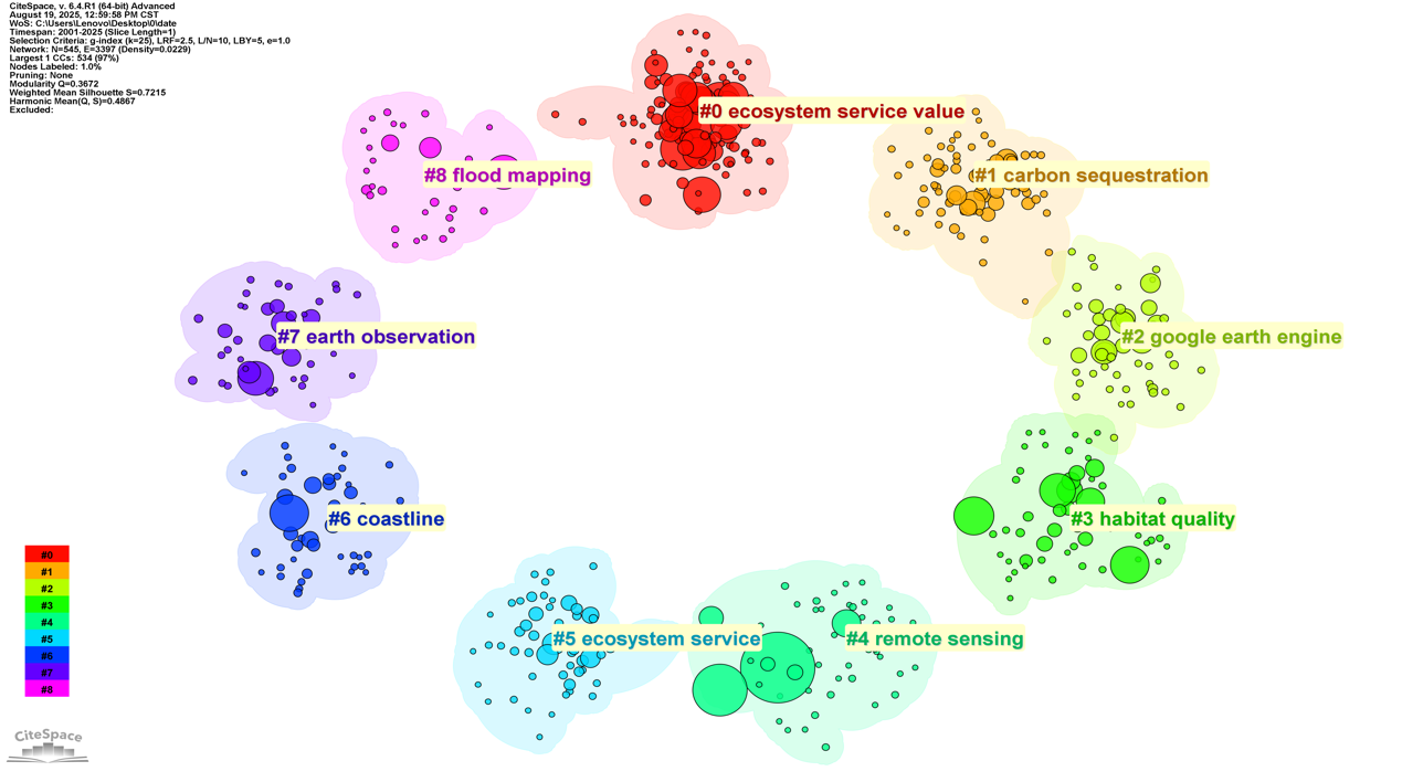
TY  - JOUR
AU  - Gu, Chengyan
AU  - Sun, Tianxu
AU  - Wang, Zhihui
AU  - Fu, Sang
PY  - 2025
DA  - 2025/11/06
TI  - Global Research Trends on Ecosystem Service Valuation Using Remote Sensing (1990–2024)
JO  - Digital Intelligence in Agriculture
T2  - Digital Intelligence in Agriculture
JF  - Digital Intelligence in Agriculture
VL  - 1
IS  - 2
SP  - 47
EP  - 60
DO  - 10.62762/DIA.2025.654827
UR  - https://www.icck.org/article/abs/DIA.2025.654827
KW  - remote sensing
KW  - ecosystem service valuation
KW  - bibliometric analysis
KW  - natural capital accounting
AB  - Ecosystem service valuation (ESV) provides a scientific basis for balancing ecological conservation and socioeconomic development. With the rapid progress of Earth observation technologies, remote sensing has become an essential tool for quantifying and mapping ecosystem services at multiple spatial and temporal scales. However, a comprehensive understanding of the global research landscape on ecosystem service valuation using remote sensing remains limited. In this study, this study conducted a bibliometric analysis of publications retrieved from the Web of Science Core Collection between 1990 and 2024. A total of 1172 articles were identified through a systematic search strategy integrating ecosystem service valuation and remote sensing keywords. The analysis employed performance indicators (e.g., publication output, citation trends, and core journals), collaboration networks (countries, institutions, and authors), and keyword co-occurrence to reveal research hotspots and emerging frontiers. The results show a steady growth of publications, with a significant surge after 2010 driven by the application of MODIS, Landsat, and Google Earth Engine in large-scale ESV studies. China, the United States, and several European countries play dominant roles in terms of both output and international collaboration. Research hotspots have shifted from conceptual frameworks and regional case studies to methodological innovations, such as spatial modeling, integration of remote sensing with ecosystem accounting frameworks, and applications in ecological security and sustainable development. This study highlights the increasing importance of remote sensing in advancing ecosystem service valuation and provides insights into future directions, including high-resolution monitoring, machine learning integration, and policy-oriented assessments.
SN  - 3069-3187
PB  - Institute of Central Computation and Knowledge
LA  - English
ER  - 
BibTeX Format
Compatible with LaTeX, BibTeX, and other reference managers
BibTeX format data for LaTeX and reference managers
@article{Gu2025Global,
  author = {Chengyan Gu and Tianxu Sun and Zhihui Wang and Sang Fu},
  title = {Global Research Trends on Ecosystem Service Valuation Using Remote Sensing (1990–2024)},
  journal = {Digital Intelligence in Agriculture},
  year = {2025},
  volume = {1},
  number = {2},
  pages = {47-60},
  doi = {10.62762/DIA.2025.654827},
  url = {https://www.icck.org/article/abs/DIA.2025.654827},
  abstract = {Ecosystem service valuation (ESV) provides a scientific basis for balancing ecological conservation and socioeconomic development. With the rapid progress of Earth observation technologies, remote sensing has become an essential tool for quantifying and mapping ecosystem services at multiple spatial and temporal scales. However, a comprehensive understanding of the global research landscape on ecosystem service valuation using remote sensing remains limited. In this study, this study conducted a bibliometric analysis of publications retrieved from the Web of Science Core Collection between 1990 and 2024. A total of 1172 articles were identified through a systematic search strategy integrating ecosystem service valuation and remote sensing keywords. The analysis employed performance indicators (e.g., publication output, citation trends, and core journals), collaboration networks (countries, institutions, and authors), and keyword co-occurrence to reveal research hotspots and emerging frontiers. The results show a steady growth of publications, with a significant surge after 2010 driven by the application of MODIS, Landsat, and Google Earth Engine in large-scale ESV studies. China, the United States, and several European countries play dominant roles in terms of both output and international collaboration. Research hotspots have shifted from conceptual frameworks and regional case studies to methodological innovations, such as spatial modeling, integration of remote sensing with ecosystem accounting frameworks, and applications in ecological security and sustainable development. This study highlights the increasing importance of remote sensing in advancing ecosystem service valuation and provides insights into future directions, including high-resolution monitoring, machine learning integration, and policy-oriented assessments.},
  keywords = {remote sensing, ecosystem service valuation, bibliometric analysis, natural capital accounting},
  issn = {3069-3187},
  publisher = {Institute of Central Computation and Knowledge}
}

Article Metrics
Citations:

Crossref

0

Scopus

0

Web of Science

0
Article Access Statistics:
Views: 868
PDF Downloads: 179

Publisher's Note
ICCK stays neutral with regard to jurisdictional claims in published maps and institutional affiliations.

Rights and Permissions
CC BY Copyright © 2025 by the Author(s). Published by Institute of Central Computation and Knowledge. This article is an open access article distributed under the terms and conditions of the Creative Commons Attribution (CC BY) license (https://creativecommons.org/licenses/by/4.0/), which permits use, sharing, adaptation, distribution and reproduction in any medium or format, as long as you give appropriate credit to the original author(s) and the source, provide a link to the Creative Commons licence, and indicate if changes were made.
Digital Intelligence in Agriculture

Digital Intelligence in Agriculture

ISSN: 3069-3187 (Online)

Email: [email protected]

Portico

Portico

All published articles are preserved here permanently:
https://www.portico.org/publishers/icck/